This week a real heat bang is in the offing – daily highs of up to 36 degrees are forecast for Tuesday – this is where the hottest is.
–
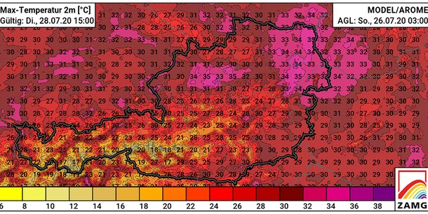
Austria-wide. A heat wave gives us daily maximum temperatures of up to 36 degrees on Tuesday – even at over 2,000 meters, values of around 20 degrees are forecast. The proverbial hotspot of the Africa heat is the northeast of the country: in Vienna, people sweat on Tuesday at temperatures of up to 36 degrees Celsius, in the western part of Lower Austria temperatures of at least 30 degrees are also forecast. But also in Upper Austria top values of 35 degrees are expected around Linz. It gets a little cooler in western Austria: Here the top values ”only” scratch the 30-degree mark.
Today’s Monday forecast: A predominantly sunny start to the week is heralded. From around noon, some cumulus clouds form temporarily, but mostly it remains dry. Individual, isolated rain showers may only be possible in the highlands. The risk of thunderstorms is correspondingly low. Mostly it is slightly windy. Early temperatures 11 to 20 degrees, maximum daily temperatures 25 to 32 degrees. Most of the night on Tuesday is mostly cloudy to starry and slightly windy. The temperatures rarely drop below 20 to 13 degrees, occasionally clouds of fog can form.
These are the hot spots on Tuesday
Wien: Tuesday will be sunny and soon very hot after a relatively pleasant morning during the day. The wind blows rather weakly from southeast to southwest. Early temperatures around 17 degrees, maximum daily temperatures around 35 Grad. From the late evening, the risk of thunderstorms and stormy gusts of west wind increases significantly.
Lower Austria: The sun shines largely undisturbed practically all day and only a few harmless clouds appear in the sky. Only weak or moderate wind blows, mainly from the south. The risk of thunderstorms and sometimes stormy gusts of west wind only increases significantly from the evening or night on Wednesday. Early temperatures 13 to 18 degrees, maximum daily temperatures around 30 to 36 Grad.
Oberösterreich: Tuesday is dominated by midsummer weather with lots of sunshine and a few high clouds. With a southwest current it gets very hot. It remains stable until the evening and is still free of thunderstorms. Only after sunset does the thunderstorm potential gradually increase from the southwest. Early values: 12 to 18 degrees, maximum temperatures: 28 to 34 Grad. Great thunderstorm danger on Wednesday night!
Burgenland: The day is sunny and hot and there are usually only a few clouds in the sky. Larger cumulus clouds should stay away from Burgenland even longer, the tendency to thunderstorms remains low during the day. The wind is weak to moderate from the south. Early temperatures 15 to 20 degrees, maximum daily temperatures 31 to 36 Grad.
Steiermark: Tuesday’s hottest day of the year is expected in Styria. When there is a lot of sunshine, the temperatures rise between 11 and 17 degrees to 30 to early 34 Grad in the afternoon.
Salzburg: On Tuesday, very summery weather with stable conditions predominates until evening. Over the course of the afternoon, a little more cumulus clouds form in the mountains, from today’s perspective it should only start to thunder here in the evening. The following night thunderstorms are more likely, which can then be very violent. Early values: 10 to 18 degrees, maximum temperatures: 29 to 35 Grad.
Tirol: The high current turns to the southwest and brings in subtropical air, which means the hottest day of summer so far. The first cumulus clouds form from noon, which become more and more extensive until evening and then discharge in the form of violent heat thunderstorms – the storm potential is high! Stormy rain follows at night. Lowest values: 13 to 17 degrees. Maximum values: 29 to 35 Grad.
Vorarlberg: The high current turns to the southwest and brings in subtropical air, which is probably the hottest day of summer so far. From noon, the first cumulus clouds form over the mountain country, which become more and more extensive by evening and then spread in the form of violent heat storms – the storm potential is high! Stormy rain follows at night. Lowest values: 14 to 19 degrees. Maximum values: 30 to 34 Grad.
Carinthia: On Tuesday there is often bright sunshine in Carinthia. In the afternoon there are mostly harmless cumulus clouds and the risk of thunderstorms is still low. Only in the evening and at night can thunderstorms develop in the north. With maximum values between 28 and 34 Grad the hottest day of the year is coming up.
–

