New Orleans is in the path of Hurricane Ida exactly 16 years from the day the city’s levees were insufficient to contain the flooding and collapsed in the face of a massive storm surge from Hurricane Katrina’s rains. Those floods killed more than 1,000 people and caused billions of dollars in damage, but Ida now comes to the doorstep of a region transformed since 2005 by a massive civil works project and increased attention to water control.
The system has already been put to the test by numerous storms, including Isaac in 2012, with very little damage to the areas it protects. However, each new meteor that hits the area raises questions about New Orleans’ defenses. As Ida approaches, here are some responses:
1) WHAT HAS CHANGED SINCE KATRINA?
The federal government spent $ 14.5 billion on levees, pumps, walls, gates and drainage that provide elevated protection against storm surge and flooding in New Orleans and the suburbs south of Lake Pontchartrain. With the exception of three drainage projects, the work is complete.
“The post-Katrina system is very different from what existed before,” said Matt Roe, a spokesman for the Army Corps of Engineers.
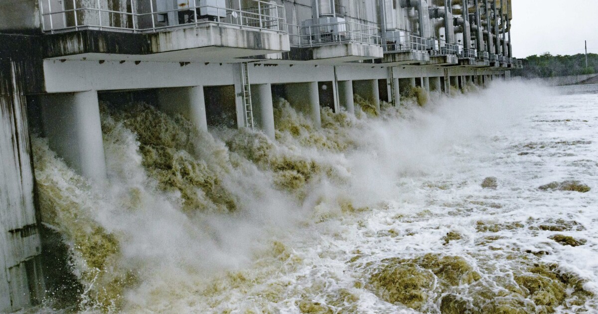
Starting with a huge storm surge barrier east of the city, the system is a 210-kilometer (130-mile) ring built to withstand a 9-meter (30-foot) storm surge.
On Friday, the National Hurricane Center projected that Ida would cause a storm surge of 4 to 4.5 meters (10 to 15 feet) on the western side. At that level, the water could overflow levees in some areas, said emergency manager Heath Jones of the New Orleans district of the Corps of Engineers.
“They are designed to be bypassed at some points,” with protections against the worst damage, including reinforcements, drains and pumps with standby generators, he said.
“We built all of that since Katrina” and they are designed for a storm much worse than Ida is expected to be, he added.
Jones said there appears to be no danger of a storm surge overflowing the levees on the eastern bank. Those levees were the ones that collapsed after Katrina.
As of Friday, governments were not ordering the evacuation of areas protected by the levees, showing confidence in the system.
Several floodgates have been closed before the arrival of the storm. That includes huge gates that allow ships to pass, like the ones that close the Inner Harbor Navigation Canal near the 9th Ward. That has reduced the risk of flooding in an area considered the most exposed in the city. At least one smaller gate on land has been removed for maintenance and authorities planned to close the gap with sandbags.
2) WHAT ABOUT FLOODS FROM SHOWERS?
Within the ring of dikes, the rainwater must be extracted with pumps. The New Orleans area has a complicated system of canals and pumps to draw water, but it can be overwhelmed by persistent rains, such as in 2017 and 2019, when two storms dumped more than 23 centimeters (9 inches) of water each in some areas. .
Showers are a constant on the US coast to the Gulf of Mexico, but some rare storms have been observed in recent years, with experts saying that those torrents are becoming more common as the warmed atmosphere has more steam.
However, capacity has been improved in some areas since 2005, with more than $ 2 billion dedicated to drainage, allowing parts of the system to remove up to 120 millimeters (4.7 inches) of rain in three hours – which designers say it’s a storm that would occur just once every 10 years.
The city’s drainage system has 24 pump stations with a combined capacity of more than 1.5 million liters (nearly 400,000 gallons) per second. That does not include the pumps in the neighboring suburbs.
But some of the pumps and electrical systems that supply them in the city are old-fashioned riddled with reliability problems. On Friday, officials were trying to restart an electric turbine in the system to provide a backup supply.
Three of 99 pumps were not working, but New Orleans Water and Sewer Commission Director Ghassan Korban said there was enough redundant system to support them.
One of the lessons of the 2017 and 2019 storms has been that drainage, pipeline and canal maintenance had been neglected. Authorities called on residents Friday to sweep around the sewers, highlighting fears that even the best pumps might not work if the drain is clogged.
“Our mission is obviously to anticipate the storm, the rains and keep the city dry,” Korban told reporters on Friday. “But at some point, once the system is overwhelmed, the mission goes from keeping the city dry to extracting the water as soon as possible.”
3) WILL THE DEVICES SUPPORT THE LONG TERM?
Experts point out that the levee system was built to withstand a level of storm surge that occurs every 100 years, something that has a 1% probability of occurring in a given year. With rising sea levels due to global warming and the sinking of Louisiana’s porous coastline, there are concerns that this is not enough.
Reports issued in 2021 recommend spending about $ 1.7 billion to raise levees and retaining walls to continue to offer a 100-year level of protection through 2078. That includes raising the height of 159 kilometers (99 miles) of levees, replacing more of 1.6 kilometers (1 mile) of walls and build 5.15 kilometers (3.2 miles) of new walls.
4) WHAT ARE THE RISKS FOR LOW AREAS?
Areas outside the urban heartland protected by the levee system may have little or no storm surge protection. In 2012, Hurricane Isaac flooded about 7,000 homes in LaPlace and other areas upstream after a 2.5-meter (8-foot) storm surge entered Lake Pontchartrain. The Corps of Engineers has begun construction of a levee to protect that area, but spokesman Rene Poche said it won’t be completed until 2024.
Several local governments have ordered evacuations of low-lying and exposed areas outside the levees, including in parts of the city.
The northern suburbs of the lake are also not protected by levees or floodgates, although improvements are being considered for the St. Tammany jurisdiction. The areas near the coast, in addition to the areas along the rivers that feed the lake and the Mississippi Sound, are vulnerable to storm surge.
–

