
Hurricane Erin Intensifies, Threatens Caribbean Islands
Table of Contents
- Hurricane Erin Intensifies, Threatens Caribbean Islands
The Atlantic hurricane season has officially entered a more active phase with the rapid intensification of Tropical Storm Erin into a hurricane on Friday. This marks the first hurricane of the 2024 season, prompting alerts and preparations across the Caribbean. The storm formed Monday east of the Cape Verde Islands and quickly gained strength, fueled by warm ocean temperatures.
Deadly Flooding preceded Hurricane Formation
Before becoming a hurricane, Erin contributed to devastating floods in the Cape Verde islands on Sunday, resulting in at least eight fatalities. Emergency teams are actively working to repair damage and address the ongoing crisis in the archipelago. Drone footage revealed widespread flooding in low-lying areas, highlighting the storm’s initial impact.
Current Status and Forecast Track
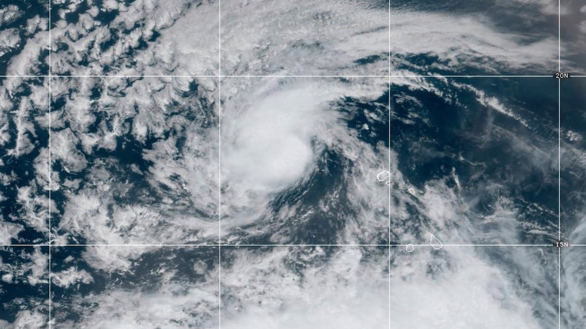
As of friday afternoon, Hurricane Erin was located approximately 365 miles (585 kilometers) east of the Lesser Antilles, moving west at 17 miles per hour (28 kilometers per hour). Maximum sustained winds reached 75 mph (120 km/h).The National Hurricane Center (NHC) forecasts a continued west-northwest trajectory over the weekend, with the storm potentially passing near or just north of the Lesser Antilles, the Virgin Islands, and Puerto Rico.
Rapid strengthening is anticipated over the next two to three days, with Erin expected to become a major hurricane - Category 3 or higher – by Sunday. The NOAA and Air Force Reserve Hurricane Hunter aircraft are scheduled to investigate the storm tonight to gather crucial data.
Tropical Storm Alerts Issued
Tropical storm alerts are currently in effect for:
- Anguilla and Barbuda
- Saint Martin and Saint Barthélemy
- Saba and Sint Eustatius
- Sint Maarten
A tropical storm alert signifies that tropical storm conditions are possible within 48 hours. Residents in these areas should closely monitor updates and prepare accordingly.
Rainfall and Potential Hazards
The NHC warns of heavy rainfall expected from Friday night through the weekend across the Lesser Antilles, the U.S. and British Virgin Islands, and southern and eastern Puerto Rico. Total rainfall amounts are projected to range from 2 to 4 inches (5 to 10 centimeters), with isolated areas potentially receiving up to 6 inches (15 centimeters). this rainfall poses a meaningful risk of flash flooding, urban flooding, and landslides.
Did You Know? The Saffir-simpson Hurricane Wind Scale categorizes hurricanes based on sustained wind speeds,with Category 3 and above classified as major hurricanes.
Intensification and Long-Term Outlook
Meteorologists predict that Erin will continue to intensify due to favorable conditions, including increasing sea surface temperatures – rising from 79°F (26°C) to 84°F (29°C) by the end of the week – and light to moderate wind shear. Though, Erin remains a relatively small system, meaning its intensity could fluctuate more rapidly than larger storms.
| Storm Name | Date of Formation | Current Status (Aug 23, 2024) | Maximum Sustained Winds | Projected Category (Aug 25, 2024) |
|---|---|---|---|---|
| Erin | August 19, 2024 | Hurricane | 75 mph (120 km/h) | Category 3 or higher |
Impact on the United States
While current long-term forecasts suggest Erin will move away from North America, the NHC cautions that it is indeed too early to definitively rule out any potential impact on the U.S. East Coast. The risk to the Lesser Antilles has increased slightly, and residents are urged to stay informed. Even if Erin maintains its trajectory, it is indeed expected to generate large ocean swells for several days, potentially causing hazardous rip currents, coastal erosion, and high surf along portions of the Antilles, Bermuda, and possibly the U.S. Atlantic coast.
pro Tip: Stay informed about hurricane updates through official sources like the National Hurricane Center (NHC) and your local National Weather Service office.
Broader Atlantic Hurricane Season Context
Erin is the fifth named storm of the 2024 Atlantic hurricane season, wich runs from June 1st to November 30th, with peak activity typically occurring between August and October. until now, the season had only produced tropical storms – Andrea, Barry, Chantal, and Dexter - making Erin the first probable hurricane. NOAA meteorologists predict an above-average season, potentially with up to 18 named storms.
Historically,storms forming near the coast of West Africa,like Erin,often veer out to sea. However, some, such as Hurricanes Irma (2017) and Florence (2018), have caused significant damage in the Caribbean and the United States. According to the National Oceanic and Atmospheric Administration (NOAA), warmer-than-average sea surface temperatures in the Atlantic Ocean are a key factor contributing to the increased likelihood of a more active hurricane season (NOAA, 2024).
What steps are you taking to prepare for potential hurricane impacts in your area? How can communities better mitigate the risks associated with these powerful storms?
Understanding Hurricane formation and Impacts
Hurricanes are among the most destructive weather phenomena on Earth, forming over warm ocean waters near the equator. They are characterized by low-pressure centers, strong winds, and heavy rainfall. The intensity of a hurricane is measured using the Saffir-Simpson hurricane Wind Scale, which categorizes storms from Category 1 to Category 5 based on sustained wind speeds. the increasing frequency and intensity of hurricanes are linked to climate change, as warmer ocean temperatures provide more energy for these storms to develop and strengthen. According to the Intergovernmental Panel on climate change (IPCC), there is high confidence that human influence has contributed to observed increases in the intensity of tropical cyclones (IPCC, 2018).
Frequently Asked Questions About Hurricane Erin
- What is the current status of hurricane Erin? Hurricane Erin is currently a Category 1 hurricane, with maximum sustained winds of 75 mph.
- Where is Hurricane Erin located? As of Friday afternoon, Erin is located approximately 365 miles east of the Lesser Antilles.
- What areas are under a tropical storm alert? Tropical storm alerts are in effect for Anguilla and Barbuda, Saint Martin and Saint Barthélemy, Saba and Sint Eustatius, and Sint Maarten.
- Is Hurricane Erin expected to hit the United States? It is indeed too early to determine if Erin will impact the U.S. east Coast,but it is being monitored closely.
- What is the forecast for Hurricane Erin’s intensity? Erin is expected to rapidly intensify and become a major hurricane (Category 3 or higher) by Sunday.
Stay tuned to world-today-news.com for the latest updates on Hurricane Erin and other developing stories. We encourage you to share this information with your friends and family and to stay safe during this hurricane season.