
Brace yourself: recent data shows extreme weather events are becoming increasingly common across the Central U.S. This article breaks down the factors behind these devastating storms, exploring the critical role of moisture, atmospheric instability, and how climate change is fueling their intensity. Learn exactly what’s creating the perfect recipe for these frightening events,and what you can expect in the future.
Recipe for Disaster: How Climate Change fuels Extreme Storms in the Central U.S.
A potent combination of moisture, atmospheric instability, and a changing climate is creating increasingly severe weather events across the heartland.

The Anatomy of a superstorm
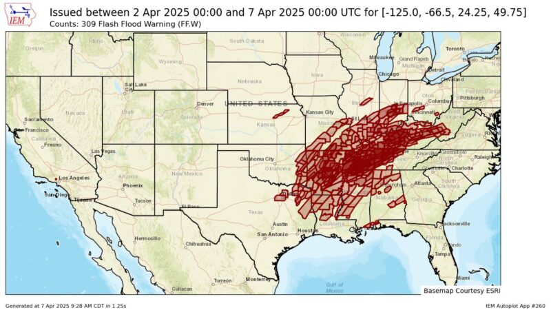
The central U.S., especially during the spring months, is a breeding ground for extreme weather. A recent storm system, which stalled over states from Texas to Ohio in early April 2025, serves as a stark reminder of this reality. The storm brought deadly tornadoes, mudslides and flooding as rivers rose,
according to the Associated Press. Some areas saw more than a foot (30 cm) of rain,
according to the Weather Prediction Center.
But what exactly fuels these devastating events? The answer lies in a combination of key atmospheric ingredients and the overarching influence of climate change.
Key Ingredients for Extreme Storms
- Moisture: Ample moisture in the air is crucial.This moisture originates from evaporating water sources and transpiration from plants.
- Atmospheric instability: This involves rising air (updrafts) and wind shear, where wind speed changes with height.
- Climate Change: Rising global temperatures exacerbate these conditions, leading to more intense and frequent storms.
The Role of Moisture
For a storm to develop, sufficient moisture must be present in the air. This moisture comes from water evaporating
off oceans, lakes, and land, and from trees and other plants.
The amount of moisture air can hold is directly related to its temperature.As Shuang-Ye Wu, a climate scientist at the University of Dayton, explains, The higher the temperature, the more moisture air can hold, and the greater potential for heavy downpours.
This is because warmer temperatures increase the kinetic energy of water molecules, making them more likely to exist in a vapor phase. In fact, the maximum amount of moisture possible in the air increases at about 7% per degree Celsius.
Moreover, warm air provides storm systems with additional energy.When water vapor condenses into liquid or ice, it releases latent heat,
which fuels the storm, leading to stronger winds and greater instability.
Atmospheric Instability: The Engine of the Storm
Atmospheric instability is the second critical component. It comprises two main elements: rising air and wind shear. Rising air, or updraft, is essential because air cools as it ascends, causing water vapor to condense and form precipitation. As air cools at higher altitudes, it begins to sink, creating a downdraft of cool, dry air on the edge of the storm system.
Wind shear plays a crucial role in the storm’s longevity and intensity.When wind shear is weak, the downdraft can suppress the updraft, causing the storm to dissipate quickly. However, strong wind shear can tilt the storm system,
allowing the updraft of warm, moist air to continue feeding the storm. This frequently enough results in powerful storm systems capable of producing tornadoes.
The Midwest: A Hotspot for Extreme Downpours
The prolonged and extensive precipitation that struck the Midwest and Southern states in early April was a direct result of these combined conditions. The Midwest is particularly vulnerable to extreme storms,especially during the spring. This is because spring marks a transitional period when cold, dry air from the Arctic clashes with warm, moist air from the Gulf of Mexico.
This clash of air masses creates atmospheric instability at the boundary, where the warm, less dense air is forced upward above the cold, denser air, leading to precipitation. The warm conditions preceding the April storm system reduced the temperature difference between the cold and warm air masses, significantly slowing the frontal movement and allowing it to stall
over a large area. this resulted in prolonged precipitation and repeated storms. The warm temperatures also increased the moisture content in the air masses,leading to heavier precipitation. Furthermore, strong wind shear ensured a continuous supply of moisture into the storm systems, fueling strong thunderstorms and dozens of tornadoes.
Climate Change: Amplifying the Threat
As global temperatures rise,
the warming air creates conditions that are more conducive to extreme precipitation. Warmer air holds more moisture, leading to wetter and stronger storms. Moreover, as the most notable warming occurs near the surface while the upper atmosphere cools, this can increase wind shear and atmospheric instability, setting the stage for even more powerful storms.
The polar regions are warming two to three times as fast
as the global average, reducing the temperature gradient between the poles and the equator. This can weaken global winds. Since most weather systems in the continental U.S.are influenced by the polar jet stream, a weaker jet stream
can slow the movement of storms, creating conditions for prolonged precipitation events.
These factors combine to create conditions that make extreme storms and flooding much more likely in the future.