
NASA’s New Radar Satellite Delivers First Images of U.S. Landscapes
WASHINGTON – NASA’s newest Earth-observing satellite, NISAR, has transmitted it’s first radar images, revealing detailed views of the Maine coast and farmland in northeastern North Dakota. The images, released today, showcase the satellite’s capability to map Earth’s land and ice with unprecedented precision, offering critical data for disaster preparedness and environmental monitoring.
The $1.3 billion joint mission between NASA and the Indian Space Research association (ISRO) promises to revolutionize how scientists track subtle changes to the planet’s surface. By monitoring shifts in land and ice, NISAR will provide vital information to forecasters and first responders dealing with events like floods, landslides, volcanic eruptions, and other natural disasters. Science operations are slated to begin in november,with the satellite expected to survey virtually all of the world’s land and ice masses multiple times.
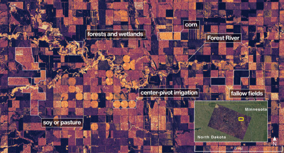
NISAR, which stands for NASA-ISRO Synthetic Aperture Radar, was launched from India two months ago and currently orbits at an altitude of 464 miles (747 kilometers) in a near-polar orbit. The released images demonstrate the satellite’s ability to distinguish features like wetlands, forests, and agricultural land. One image highlights the land adjacent to northeastern North Dakota’s Forest River, showcasing light-colored wetlands and forests alongside circular and rectangular plots likely representing pasture or cropland planted with corn or soy.
NASA officials say these initial images are merely a preview of the wealth of data NISAR will deliver,enhancing understanding of Earth’s dynamic systems and improving responses to global challenges.
(Image provided by NASA/JPL-Caltech on Aug. 23, 2025, shows NISAR imaging land adjacent to northeastern North Dakota’s Forest River.)