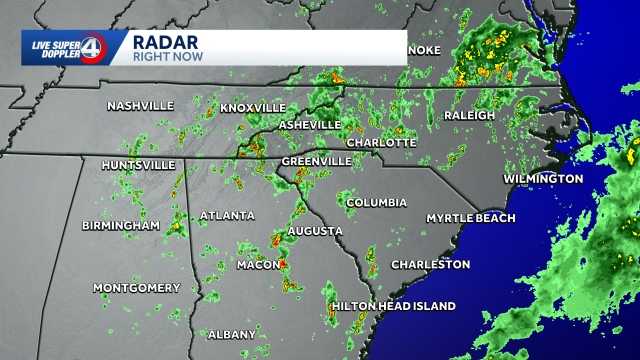
South Carolina Weekend Weather: Rain and Cooling Temperatures Arrive
Heavy weekend rain is heading toward South Carolina, bringing up to three inches of accumulation and dropping high temperatures into the 60s following an approaching cold front, wyff4.com reported on October 2. The shift arrives after a hot October Friday with feels-like temperatures reaching the 90s.
Hot Friday Precedes Weekend Cold Front Across South Carolina
Friday starts as a warm October day across the region, with humidity pushing feels-like temperatures into the 90s. Conditions shift quickly by Saturday morning. While the day begins dry with scattered afternoon showers allowing temperatures to climb into the 80s, rain coverage and intensity increase significantly by Saturday evening.
A cold front arrives on Sunday, bringing continuous rain for the majority of the day. Rain totals across the region are projected to range between one and three inches. Following the front, high temperatures will drop sharply into the 60s.
Football Fans Face Wet Conditions and Gear Adjustments
Anyone attending football games this weekend will need to pack a raincoat or rain poncho to handle the steady moisture and dropping temperatures.
Independent Forecasters Confirm Local Weather Accuracy
The incoming weather shift is tracked by the WYFF News 4 weather team, which has been independently certified for having the most accurate forecast in the Greenville-Spartanburg-Asheville-Anderson market for the second year in a row.

“Our goal every day, in every forecast, is accuracy,” WYFF 4 President and General Manager Blake Bridges stated. “Our expert weather team is dedicated to giving viewers a forecast they can trust to be right. We are also the only station in the market with our own 24/7 live radar, Live Super Doppler 4.”
The certification was awarded by WeatheRate, an independent research firm tracking forecasts across multiple markets nationwide. “Everyone knows that forecasting the weather around here is difficult with the Upstate and mountains,” WeatheRate President Bruce Fixman said. “The station that gets the forecast right more than anyone else is Chief Meteorologist Chris Justus and the WYFF News 4 weather team.”
Tracking the Storms via Live Super Doppler 4
Current temperatures and regional radar trends are tracked continuously as the cold front approaches the state. Residents preparing for the weekend weather change can follow updates through the station’s 24/7 live radar coverage to monitor storm intensity and rainfall totals across local communities.