Random Forest and CatBoost Outperform MLR and XGBoost in Turbid Lagoon Bathymetry
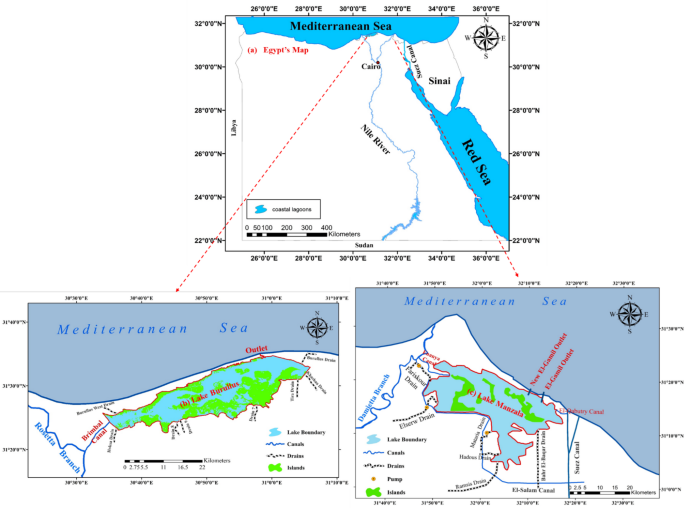
Researchers evaluating satellite-derived bathymetry (SDB) in optically complex coastal lagoons have identified that linear regression models struggle to account for the extreme turbidity found in systems like Egypt’s Lake Burullus and Lake Manzala.
The study analyzed 26 spectral variables, eventually narrowing the selection to eight predictors—including deglinted blue and red bands and the Differential Index DII—to establish a baseline for depth estimation. While the empirical multiple regression (MLR) model provided a consistent benchmark, it accounted for only 25% of the variance in Lake Burullus and exhibited systematic underestimation in deeper navigation channels.
The transition from linear models to machine learning algorithms revealed significant trade-offs between predictive accuracy and overfitting. Training data indicated that XGBoost achieved high apparent accuracy with an R² of 0.96, yet this performance dropped to 0.73 during independent validation. This divergence highlights the challenge of deploying complex models in environments where site-specific spectral variations can skew results.
| Model | Lake Burullus R² (Validation) | Lake Burullus RMSE (m) |
|---|---|---|
| Random Forest | 0.79 | 0.16 |
| CatBoost | 0.76 | 0.17 |
| MLP | 0.67 | N/A |
| SVR | 0.57 | 0.18 |
Random Forest and CatBoost models demonstrated superior stability, maintaining more consistent performance across both training and validation datasets. These algorithms proved better at handling the spectral interference caused by submerged vegetation and high bottom-albedo variability. The research shows that even with advanced machine learning, depth retrieval remains constrained by the inherent physics of turbid water, where absorption and scattering can mask the bottom-reflected signal at depths exceeding 0.8 meters.
The study found that depths below 0.7 meters were frequently overestimated due to the influence of shallow-water bottom types and mixed-pixel effects. Conversely, navigation channels deeper than 2.5 meters were consistently underestimated.
Lake Burullus, a brackish lagoon in Egypt’s Nile Delta within Kafr el-Sheikh Governorate, is separated from the Mediterranean Sea by a 5.5 km strip of land and connected only by a narrow 250 m outlet.
Agriculture drainage water accounts for 97% of its annual inflow of 3.9 billion m³, a hydrological regime that has driven salinity down and reduced recorded fish species from 52 at the start of the 20th century to 33 today. The lake contains roughly 50 islands and is designated a Wetland of International Importance under the Ramsar Convention.
The inability of the models to distinguish between depth-related light attenuation and the optical signature of suspended sediments remains a primary hurdle for autonomous coastal monitoring. The research indicates that future improvements will rely on capturing the nonlinear interactions between turbidity gradients and water-column depth, rather than increasing the complexity of the linear baseline.