
Most of Japan‘s Coastal Towns Lack Critical Storm Surge Maps, Leaving Millions Vulnerable
TOKYO – A new investigation by The Asahi shimbun reveals that approximately 70 percent of Japan’s coastal municipalities have not yet created legally mandated storm surge hazard maps, possibly endangering millions of residents as the threat of increasingly powerful typhoons grows.
These maps, often referred to as a “compass” for safety, detail flood-prone areas, anticipated water depths, and designated evacuation routes. Their absence leaves communities unprepared for the dangers of storm surges – rises in sea level caused by typhoons or low-pressure systems that can overwhelm coastal defenses.
Japan’s Flood Prevention Law requires the 705 municipalities within designated danger zones across 39 coastal prefectures to develop these hazard maps. However, as of June, only 230 municipalities (32.6 percent) had completed them, with the majority located in Tokyo, aichi, Osaka, and Fukuoka prefectures.
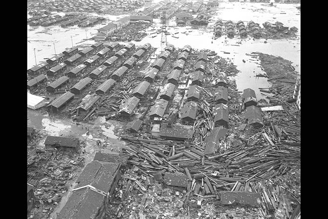
The lack of preparedness is particularly concerning given the past devastation caused by storm surges. The 1959 Ise Bay Typhoon resulted in over 5,000 deaths or missing persons in Aichi and Mie prefectures, while hurricane Katrina’s storm surge in the United States in 2005 claimed more than 1,800 lives. experts predict the risk of such events will increase with climate change and more extreme weather patterns.
A key obstacle to map creation is the slow pace of flood zone designation at the local level. The land ministry has set a deadline of March 2026 for local governments to complete these designations. As of august, only 14 of the 39 coastal prefectures - including Kanagawa, Osaka, and Fukuoka – had finished the process. Four prefectures, including Hokkaido and Tokyo, have partially designated areas, while 21 have yet to begin.
without designated flood zones,municipalities cannot proceed with hazard map development. Identifying vulnerable areas requires complex simulations of various typhoon scenarios, a process hampered by budget constraints, staffing shortages, and a lack of specialized technical expertise, according to ten of the 25 prefectures that have not completed designations.