Canary Islands weather shifts as Tropical Storm Gonzalo brings rain
The Canary Islands are experiencing a shift in weather as humidity and cloud cover associated with the remnants of Tropical Storm Gonzalo move into the archipelago.
National Hurricane Center and Meteored Track the System’s Evolution
The United States National Hurricane Center (NHC) in Miami confirmed on Saturday night that Gonzalo had ceased to be a tropical cyclone while positioned north of Cape Verde. At the time of its final advisory, the system sustained maximum winds of approximately 65 kilometers per hour. Although the storm itself will bypass the islands entirely, the lingering moisture field poses forecasting challenges due to differing model projections regarding its exact path and activity.
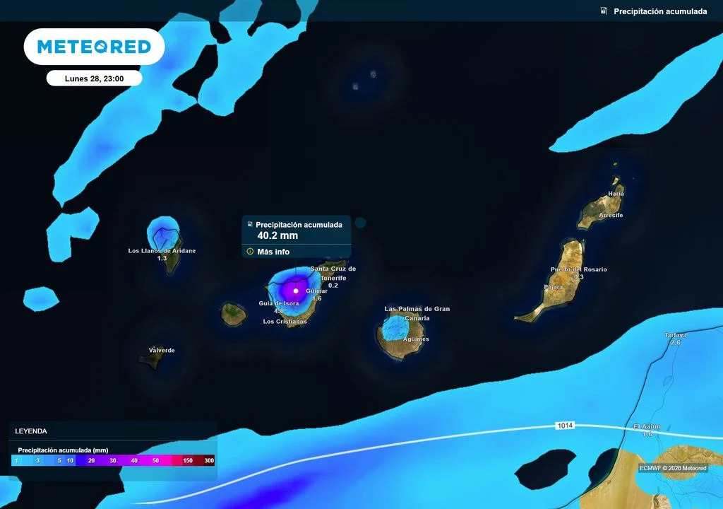
Meteored notes that the associated cloud band will advance toward La Palma, Tenerife, La Gomera, El Hierro, and Gran Canaria. Mountainous relief will likely enhance precipitation on favorable slopes where moist air ascends. The European weather model indicates that some western areas could accumulate more than 30 to 40 liters of water per square meter throughout the episode, though overall rainfall distribution will remain highly uneven.
AEMET Forecasts Monday Showers and Decreasing Calima
The State Meteorological Agency (AEMET) forecasts continued instability for Monday, warning of broken cloud cover, occasional showers, and the possibility of isolated thunderstorms during the early morning hours. In Tenerife, morning clouds are expected primarily in the southern districts, with a low probability of occasional rain before clearing slightly in the afternoon. Interior regions, however, carry a higher probability of precipitation as clouds build later in the day.
Similar conditions are anticipated across Gran Canaria, La Gomera, La Palma, and El Hierro, where overnight thunderstorms remain a possibility. In Lanzarote and Fuerteventura, cloud cover will dominate the first half of Monday alongside low chances of scattered rain before skies clear in the afternoon. This shift in weather patterns will coincide with a gradual reduction of the haze (calima) lingering in the upper atmosphere.
Temperatures and Wind Conditions Across the Archipelago
Despite a slight temperature drop in certain areas, warm conditions will persist across the islands. Thermometers may locally reach or exceed 30 degrees Celsius in regions of Tenerife, Gran Canaria, Lanzarote, Fuerteventura, La Gomera, La Palma, and El Hierro. Capital cities will experience daytime highs of 30 degrees Celsius in Santa Cruz de Tenerife and 28 degrees Celsius in Las Palmas de Gran Canaria, with overnight lows holding steady at 24 degrees Celsius in both locations.
Winds will generally remain light from an easterly component, shifting to a coastal breeze regime by the afternoon. Meanwhile, higher mountain peaks on the more relief-heavy islands will experience light westerly winds. Farmers, municipal planners, and residents monitoring the changing conditions can consult agricultural extension services and local civil protection authorities for updates on localized precipitation and wind shifts.