
Ancient Antarctic Rivers Carved Hidden Landscape
30 Million-Year-Old Features Found Beneath Ice Sheet
Scientists have uncovered a vast, ancient terrain preserved deep within East Antarctica, buried for an estimated 30 million years. This discovery sheds light on the continent’s geological past and could significantly refine predictions about future ice loss.
Unveiling a Subglacial World
New research reveals that colossal, flat surfaces beneath the Antarctic Ice Sheet were sculpted by ancient rivers between 80 and 34 million years ago. These erosional features, previously only hinted at in fragmented data, have now been mapped, offering a clearer picture of Antarctica’s evolution.
“We’ve long been intrigued and puzzled about fragments of evidence for ‘flat’ landscapes beneath the Antarctic ice sheets,” stated **Neil Ross**, a geophysicist at Newcastle University. “This study brings the jigsaw pieces of data together, to reveal the big picture: how these ancient surfaces formed, their role in determining the present-day flow of the ice, and their possible influence on how the East Antarctic Ice Sheet will evolve in a warming world.”
The potential melting of the entire East Antarctic Ice Sheet could lead to a catastrophic sea-level rise of over 160 feet (50 meters). Understanding the conditions at the ice sheet’s base and its historical behavior is crucial for accurate climate modeling.
River Systems Shaping Ice Flow
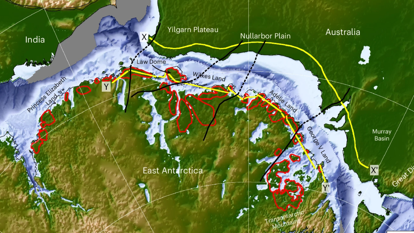
Using radar data from multiple surveys, researchers mapped the topography of the bedrock concealed by ice. This analysis identified extensive flat expanses, interspersed with deep troughs, covering a significant 2,175-mile (3,500 kilometers) stretch of the East Antarctic coast.
“When we were examining the radar images of the sub-ice topography in this region, these remarkably flat surfaces started to pop out almost everywhere we looked,” explained **Guy Paxman**, a polar geophysicist at Durham University. “The flat surfaces we have found have managed to survive relatively intact for over 30 million years, indicating that parts of the ice sheet have preserved rather than eroded the landscape.”
These ancient plains likely formed after the breakup of the supercontinent Gondwana, which once included Antarctica, Australia, Africa, and India. The researchers pinpointed the formation period to between 80 and 34 million years ago.
The current ice flow dynamics are directly influenced by these ancient features. Ice moves relatively slowly over the flat bedrock but accelerates significantly in the deeper troughs. These troughs may have been carved by meltwater flowing through natural depressions as the East Antarctic Ice Sheet expanded millions of years ago.
The stability of ice resting on these ancient, flat surfaces could be a key factor in regulating ice loss from the continent. Further investigations, including the analysis of rock samples from beneath the ice, are planned to enhance our understanding.
“Information such as the shape and geology of the newly mapped surfaces will help improve our understanding of how ice flows at the edge of East Antarctica,” **Paxman** added. “This in turn will help make it easier to predict how the East Antarctic Ice Sheet could affect sea levels under different levels of climate warming in the future.”
A recent study published in *Nature Climate Change* indicates that even a moderate 1.5°C warming could commit Antarctica to significant long-term sea-level rise, underscoring the importance of detailed subglacial mapping (Nature Climate Change, 2023).