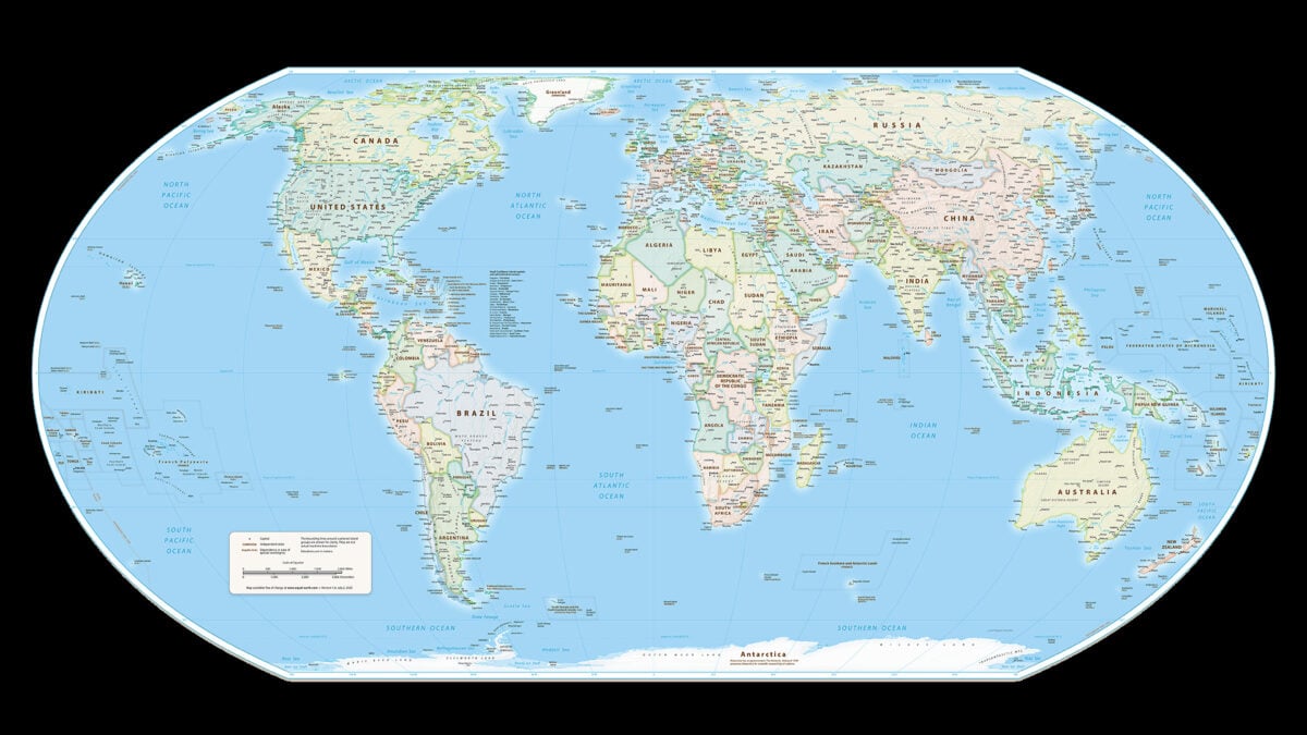
UN Approves Equal Earth Map to Show Africa’s True Size
The United Nations General Assembly voted on Friday, September 4, 2026, to adopt a resolution shifting away from the 16th-century Mercator global map toward the Equal Earth projection, a cartographic standard designed to accurately reflect the true size of continental landmasses and counter perceptions that the African continent is peripheral. Sponsored by African states, the initiative was led by Togo to address colonial-era legacies embedded in standard educational and digital infrastructure.
The Tech TL;DR:
- The Shift: The UN General Assembly voted 164-1 with 6 abstentions to endorse the Equal Earth projection over the centuries-old Mercator map.
- The Technical Distortion: The Mercator projection expands landmasses near the poles, making Greenland appear roughly equal to Africa, whereas Africa is actually about 14 times larger.
- Implementation Roadmap: Togo plans to update school geography materials by the end of the year and engage technology companies operating mapping and GPS systems.
Cartographic Architecture and the Mercator Distortion Problem
For centuries, digital mapping engines, GIS platforms, and classroom globes have relied on the Mercator projection, formulated in 1569 by Flemish cartographer Gerardus Mercator. While the projection accurately preserves angles and local directions—making it indispensable for maritime and aerial navigation—it introduces severe visual scaling anomalies as latitude increases. According to background details from Reuters, these mathematical distortions inflate landmasses near the poles while compressing regions near the equator.
This architectural flaw results in a visual rendering where Greenland appears roughly equivalent in scale to the entire African continent, despite Africa boasting a landmass roughly 14 times larger. French Foreign Minister Jean-Noel Barrot noted in an official statement that under the Mercator model, the United States, Russia, and China assume a disproportionate visual prominence compared to Latin America, southeast Asia, and Africa. To rectify this database representation, engineers and cartographers utilize equal-area projections like Equal Earth, which maintain correct relative proportions between regions.
The resolution explicitly specifies that the Equal Earth endorsement is non-binding and “in no way challenges the use of Mercator projection for maritime and aerial navigation, for which it remains fully suited,” as highlighted in statements from the Togolese ministry reported by Reuters.
Global Voting Alignment and Implementation Strategies
The resolution passed with overwhelming support in the UN General Assembly, securing 164 votes in favor, 6 abstentions, and a single opposing vote from the United States. According to United States representative Yaryna Ferencevych, the U.S. delegation opposed the measure on the grounds that it promoted an “ideological agenda” and functioned as a distraction from genuine challenges concerning international peace and prosperity. Estonia, Georgia, Lithuania, Morocco, Serbia, and Ukraine abstained from the vote.
Conversely, co-sponsors such as France backed the shift. French Foreign Minister Jean-Noel Barrot stated that correcting a distorted representation serves as an act of truth. Togo’s Foreign Minister Robert Dussey emphasized to Reuters that his administration intends to overhaul national geography curriculums before the end of the year. “Togo will be the first country to change our own geography books,” Dussey stated, noting that the initiative will require direct coordination with software enterprises managing GPS, location-based services, and digital mapping infrastructure.
{
  "projection": "Equal Earth",
  "srs": "+proj=eqearth +lon_0=0 +x_0=0 +y_0=0 +datum=WGS84 +units=m +no_defs",
  "bounds": [-180, -90, 180, 90],
  "supported_clients": ["Leaflet", "Mapbox GL", "OpenLayers"]
}
Future Roadmap for Location-Based Technologies and GIS Integration
Togo plans to engage African Union member states and international allies over the next six months to establish standardized guidelines for map adoption across public and private sectors.

*Disclaimer: The technical analyses and security protocols detailed in this article are for informational purposes only. Always consult with certified IT and cybersecurity professionals before altering enterprise networks or handling sensitive data.*
- Blizzard Cinematic Reveal Set for BlizzCon Amid WoW 2 and Camelot Leaks
- Modders Unlock RTX 50 DLSS Multi Frame Generation for RTX 40 GPUs
- Reinventing Development Evaluation in Africa Through Local Ownership (newsdirectory3.com)
- UN Adopts New Map to Accurately Reflect Africa’s True Size (newsy-today.com)