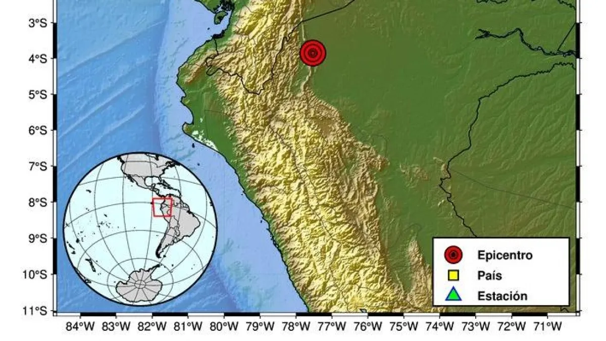
Magnitude 6.9 Earthquake Strikes Central Perú on Nov 20, Felt in Bogotá
A magnitude 6.9 earthquake struck central Peru on Friday at 7:09 p.m. local time, triggering evacuations as far away as Bogotá, Colombia.
The tremor occurred at 19:09 local time (00:09 GMT Saturday) with an epicenter 30 kilometers northwest of the rural population of Junín. While initial reports from the Servicio Geológico Colombiano (SGC) measured the event at 6.9 magnitude with a depth of 142 kilometers, international monitoring agencies provided slightly varied data regarding the seismic intensity and location.
The SGC map placed the epicenter in Peruvian territory near the coast, while other reports specifically identified the location as the area of Ondores.
The United States Geological Survey (USGS) and the Instituto Geofísico del Perú (IGP) adjusted their findings to a 6.7 magnitude. The IGP specified the epicenter was 30 kilometers northwest of Junín, at a depth of 129 kilometers, according to reports published by El Tiempo.
The depth of the tremor explains why the shaking was felt across such a wide geographic area, including parts of Ecuador and Colombia. The IGP reported an intensity of V in Junín, while the USGS placed the epicenter nine kilometers northeast of Carhuamayo.
🔴Así se sintió en Colombia el fuerte temblor de magnitud 6,9 registrado en Perú en la noche de este viernes 20 de noviembre. A través de redes sociales, ciudadanos captaron el movimiento telúrico. Imágenes 📹👇 Más detalles aquí ⬇️https://t.co/sXXVhcoTrn Videos: HORCAUCA en… pic.twitter.com/2oCOGbHlBT
Rockfalls Block Transit Routes and Damage Buildings in Junín
Authorities in Peru have reported limited structural damage, primarily concentrated in the Junín region. Luis Vásquez, chief of the Instituto Nacional de Defensa Civil (Indeci), told TV Perú that rockfalls have blocked key transit routes, specifically the road from Tarma to Junín and sections between Lima and Huancayo, according to El Tiempo.
Minor damage was also noted at the hospital in Pichanaki and the Universidad Peruana de Los Andes.
DW reported that at least one person, a young woman in Lima, sustained a head injury after being struck by falling concrete in the city’s historic center. Local government assessments indicate that 39 homes across the districts of San Pedro de Cajas, Ulcumayo, Ticlacayán, and Pichanaki suffered cracking or other structural impairments.
In Lima, where the tremor was felt moderately, there were some landslides in the Independencia district, and rocks fell from cliffs along the Costa Verde, though no accidents were reported. Despite the wide reach of the seismic waves, power outages were described as momentary by local officials in Chanchamayo and Pasco.
#AHORA 🚨 El #Minsa, a través del COES Salud y el EMED de la Diresa Junín, viene monitoreando daños tras el sismo ocurrido en esta región. 🇵🇪 [Información en desarrollo] pic.twitter.com/VvpeiDEfzN
Seismic Data Discrepancies
| Agency | Magnitude | Depth (km) |
|---|---|---|
| Servicio Geológico Colombiano | 6.9 | 142 |
| Instituto Geofísico del Perú | 6.7 | 129 |
| USGS | 6.7 | 108 |
The variance in these figures stems from differing methodologies in seismic wave processing. Hernando Tavera, head of the IGP, explained to RPP that the tremor’s intermediate depth resulted in a broader radius of perception and a longer duration of shaking, according to Revista Semana.
He clarified that there is no scientific basis for theories circulating on social media suggesting a sequential pattern of earthquakes across the Pacific Ring of Fire, which spans 40,000 kilometers.
Emergency Evacuations Ordered as Tsunami Threat Ruled Out
The event prompted immediate emergency protocols in Colombia, where residents in Bogotá and Cúcuta evacuated buildings as a precaution. The Unidad Nacional para la Gestión del Riesgo de Desastres (UNGRD) confirmed that, based on data from the Dirección General Marítima (Dimar), there was no tsunami threat to the Colombian Pacific coast.
Similarly, the U.S. National Tsunami Warning Center ruled out any tsunami risk for California, Oregon, Washington, British Columbia, and Alaska.

Assessing the impact on critical infrastructure—such as the Upamayo dam near the epicenter—remains a priority for local municipal authorities.
The Instituto Geofísico del Perú traces its origins to 1922 with the founding of the Huancayo Magnetic Observatory, considered the cradle of the institution.
It was renamed the Instituto Geofísico de Huancayo in 1947, expanding into seismology and atmospheric physics, before adopting its current name and moving its headquarters to Lima in 1962. That decade also saw the establishment of the Jicamarca Radio Observatory, home to a 300-by-300-meter radar for ionospheric study.
As recovery efforts continue, the focus shifts toward structural inspections and the restoration of normal traffic flow in the affected provinces. “Se sigue recorriendo los lugares más alejados. Tenemos en este momento gente de las municipalidades que se está dirigiendo a los diferentes sectores para ver si tenemos algún impacto de daño con la finalidad de inmediatamente movilizar ayuda humanitaria,” said Vásquez.
#SismosColombiaSGC Evento Sísmico Internacional – Boletín Preliminar, 2026-11-20, 19:09 hora local. Magnitud 6.9. Profundidad superficial #NoticiaEnDesarrollo #Temblor #Sismo Más información: https://t.co/63pt8nVsSe pic.twitter.com/TrzRnI9vhI
More on Bogotá
Temblor en Lima #temblor #sismo #peru pic.twitter.com/GQwnerEgRR
EXTRA | En videos: así fue el fuerte sismo de 6,9 en Perú. Por ahora no se reportan afectaciones. pic.twitter.com/tcNNm5r8HE
@Sismos_Peru_IGP informa sismo de magnitud 6.7 ocurrido a 30 km al NO de Junín, Junín – Junín. pic.twitter.com/xycsmFiatg
#ATENCIÓN | En plena película: así fue la evacuación en un cine de Perú tras el fuerte sismo de 6,9. pic.twitter.com/Dhk37B7Ux9