Colorado Wildfire Rages South, Forcing New Evacuations
Lee Fire Explodes to Over 92,000 Acres, Creating Its Own Weather
A massive wildfire in western Colorado is accelerating southward, prompting authorities to establish new evacuation zones as the blaze intensifies. The Lee Fire, now one of the largest in state history, is a growing threat to communities and infrastructure.
Lee Fire’s Southern Surge
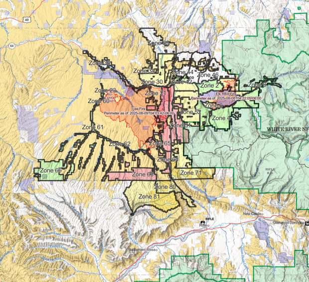
The Lee Fire, located southwest of Meeker, has dramatically increased in size. By Saturday afternoon, it had consumed 92,047 acres, a significant jump from the 88,877 acres reported Friday morning. Critically, the fire remains entirely uncontained, with no percentage of containment reported by officials.
In stark contrast, the Elk Fire, situated southeast of Meeker, has achieved 8% containment and burned 14,635 acres. Combined, over 1,200 personnel are battling these two significant wildfires.
Meeker Evacuation Status Changes
While Meeker itself saw its evacuation status downgraded to “ready” on Friday evening due to favorable wind shifts, the fire’s southward push has necessitated new evacuation orders. Zones 63 and 70, south of the Lee Fire, are now under a mandatory “Go” order, meaning residents must evacuate immediately.
The Garfield County Sheriff’s Office advises those in these “Go” zones to travel south on County Road 253 (Piceance Creek Road) to Highway 13, then proceed to Rifle. Local traffic will be permitted through this closed route.
Expanding Evacuation Alerts
Further south, along the northern edge of Garfield County, zones 80 and 81 have been placed in “Set” status, indicating a likely short-notice evacuation. Residents are urged to prepare to leave and are advised to evacuate now if they require more time.
Zone 66 is now in “Ready” status, signaling that an evacuation in this area is possible. Residents are encouraged to pack essential belongings and stay informed about changing fire conditions.

Even areas further afield, such as Rifle and Parachute, are experiencing ash and smoke. While Rifle is not under evacuation orders, the Rifle Correctional Center is being evacuated. Residents can find an updated list of evacuation zones at this link.
Fire Creates Its Own Weather
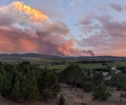
The sheer intensity of the Lee Fire is generating its own weather patterns. Officials report that pyrocumulus clouds, formed by intense convection, are reaching heights of 30,000 feet. This phenomenon, coupled with atmospheric moisture, means the fire is actively creating its own winds and fueling its rapid spread.
Operations Planning Chief **Tyler Nathe** acknowledged the ongoing challenge, stating, There’s still a lot of work left to be done and a lot of risk still out there for this thing to keep going.
He emphasized the team’s focus: staying focused, and staying energized on what we’re here to do, and that’s to protect people and their property and do it safely.
According to the National Interagency Fire Center, as of August 10, 2025, there were 23 large wildfires burning across the United States, covering over 470,000 acres.
Resources and Outlook
Shelters are available for evacuees at Moffat County High School in Craig and the Church of Jesus Christ of Latter Day Saints in Rangley. An evacuation center is also operational at the Fairfield Center in Meeker, and the Rio Blanco County Fairgrounds is providing emergency shelter for livestock.
Firefighters are strategizing to use Highway 13 as a potential fire break to prevent the blaze from moving east. However, they caution that the fight is far from over, with significant risks still present.