Typhoon 9 Alert: Severe Winds and Flight Disruptions Hit Okinawa and Japan
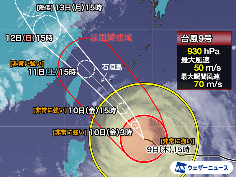
Typhoon No. 9, a large and extremely strong storm, is projected to pass near the Sakishima Islands between July 10 and 11, 2026, according to WeatherNews. The system carries a vast wind field capable of causing residential collapses in Okinawa due to violent winds, while threatening the Pacific coast of mainland Japan with massive swells.
The scale of this system is not typical. Unlike smaller, concentrated storms, Typhoon No. 9 is characterized by a “broad area of gale-force winds,” which WeatherNews reports will extend the duration and geographic reach of the impact. This means that even areas far from the center of the eye will experience prolonged wind stress and heavy precipitation.
Okinawa Faces Potential Structural Failure by July 11
The most immediate danger centers on the Okinawa region, where the storm is expected to make its closest approach by the morning of July 11. FNN Prime Online reports that the intensity of the winds is severe enough to pose a direct threat of house collapses. When wind speeds reach the levels associated with “extremely strong” typhoons, traditional building reinforcements can fail, turning debris into lethal projectiles.

TBS News Dig reports that over 80 flights, primarily centered around Okinawa, were canceled for July 10. ANA has already extended these cancellations into July 11.
The sheer physical force of the storm is difficult to quantify for the average resident. ABEMA Times highlighted an analysis by a weather forecaster explaining the “danger” of 70-meter-per-second winds, noting that such speeds can move heavy objects and compromise structural integrity. This level of wind is not merely disruptive; it is destructive.
Mainland Japan: High Seas and Heatwaves
While the wind center targets the south, the ripple effects will be felt across the Japanese archipelago. WeatherNews warns that the Pacific side of Honshu must prepare for “one-shot” massive waves—sudden, powerful swells that can overwhelm coastal defenses and endanger swimmers or maritime operations.
Paradoxically, the storm’s trajectory may exacerbate heat issues elsewhere. FNN Prime Online indicates that Western and Eastern Japan are likely to experience intense heatwaves as the storm’s movement influences atmospheric pressure and pushes warm air toward the mainland.
| Region | Primary Threat | Expected Timing | Source |
|---|---|---|---|
| Sakishima Islands/Okinawa | Violent winds, home collapse | July 10–11 | FNN / WeatherNews |
| Pacific Coast (Honshu) | Massive swells/High waves | July 11 onward | WeatherNews |
| West/East Japan | Extreme heat/Heatwaves | Concurrent with storm | FNN Prime Online |
Infrastructure Vulnerabilities and Economic Friction
The Japan Meteorological Agency (JMA) and the Japan Meteorological Agency provide the primary data for these alerts, which are then disseminated through outlets like WeatherNews.
The "severe caution" advisory issued by WeatherNews is not a suggestion; it is a warning based on the storm's "extremely strong" classification.
As Typhoon No. 9 moves toward the islands, the focus shifts from prediction to survival.