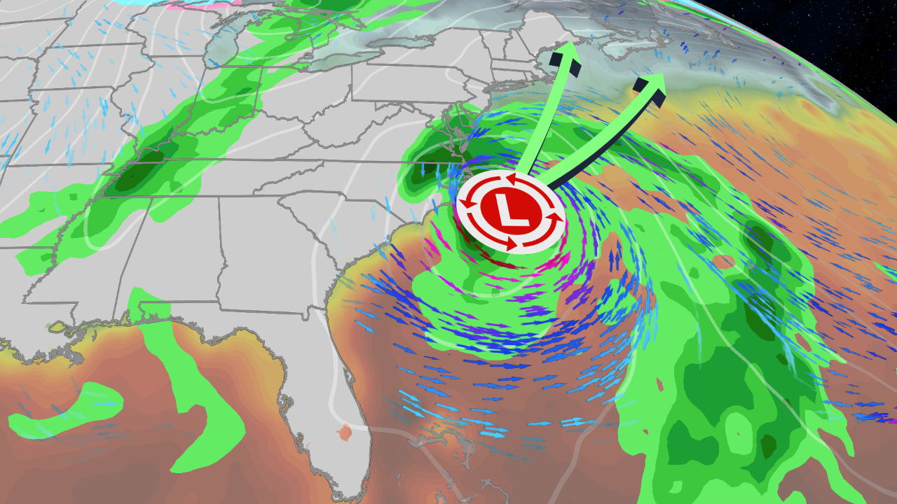
Tropical Storm Kyle Could Threaten East Coast This Weekend
A storm brewing off Florida could become Tropical Storm Kyle and push rain, wind and coastal flooding up the Atlantic Seaboard from this weekend into early next week, with possible landfalls in North Carolina on Sunday and Nova Scotia by Tuesday, AccuWeather reported.
AccuWeather meteorologists raised the tropical development potential to a high risk on Wednesday and are calling the system a tropical wind and rainstorm so the public prepares even if it never earns a name, AccuWeather reported. The National Hurricane Center has circled the same area for possible development, and Weather.com senior meteorologist Jonathan Erdman noted those chances are growing.
The system is forecast to take shape early Friday over the northern Bahamas, just east of Florida’s Atlantic coast, then curve north along the shoreline. Steering winds and the varying coastline could bring it close enough to make landfall in North Carolina, Cape Cod or Nova Scotia, according to AccuWeather’s forecast.
AccuWeather assigned the storm a RealImpact Scale rating of 1, a measure that weighs rain, flooding, surge, erosion and economic losses alongside wind speed.

“The brewing tropical wind and rainstorm could cause significant coastal impacts along the North Carolina and mid-Atlantic coastline,” said AccuWeather Senior Meteorologist Alan Reppert. “Portions of the North Carolina Outer Banks have sustained significant coastal flooding and beach erosion this season. Additional impacts, especially to North Carolina Highway 12 on Hatteras Island, could lead to road closures.”
Outer Banks braced for a second blow
The stakes are highest where the coast is already broken. A 1,600-foot section of North Carolina Highway 12 near the Pea Island Visitor Center washed out twice during September and October storms, and sandbags have not fully secured it, AccuWeather reported. The highway remained closed as of Oct. 21.
Reppert warned that a close pass by the storm center could further damage dunes and coastal infrastructure already battered this season.
Outer Banks face 60-80 mph gusts
Worst conditions fall near and east of the center. AccuWeather’s forecast puts gusts of 40-60 mph on the South Carolina coast this weekend, spreading into central North Carolina, southeastern Virginia, the Delmarva shoreline and the New Jersey coast. The Outer Banks face the strongest zone: 60-80 mph.
| Region | Wind gusts | Timing |
|---|---|---|
| South Carolina coast to New Jersey shore | 40-60 mph | This weekend |
| North Carolina Outer Banks | 60-80 mph | This weekend |
| Long Island, southeastern New England | 40-60 mph | Sunday to Monday |
| Cape Cod, Nantucket, Martha’s Vineyard | 60-80 mph | Sunday to Monday |
| Nova Scotia, Newfoundland | 40-60 mph | Early next week |
The Local StormMax wind gust is 90 mph, AccuWeather said.
Rain should be the lesser threat because the storm moves fast. A general 1-4 inches is forecast from northeastern Florida to southeastern New England and part of southeastern Canada from Friday to Monday. Eastern North Carolina, mainly the Outer Banks, could pick up 4-8 inches, with a Local StormMax of 20 inches. By the time the rain reaches New England and Atlantic Canada, it may last only 12-18 hours.
Florida is not waiting for the storm. Close to 10 inches fell on the Fort Lauderdale area in less than 24 hours at midweek, and 10-18 inches has soaked parts of the southern and eastern peninsula this week, according to AccuWeather. Record flooding now grips the St. Johns River near Cocoa, with further rises forecast downstream through central Florida.
Will it become Kyle?
The name depends on structure, not track. Weather.com’s Erdman reported the low could sit over the warm Gulf Stream, allowing thunderstorms to build near its center and transform it into a subtropical or tropical storm.
With winds of at least 40 mph and enough storm activity, it would be named Subtropical or Tropical Storm Kyle. A subtropical system carries a mix of tropical and cold-core features, and the hurricane center monitors it the same way.
A second storm center could also form, complicating the track and the rain and wind picture in the Northeast later in the weekend, AccuWeather reported. There is still a chance the whole system stays at sea or turns east, which would sharply reduce impacts from North Carolina to New England.
Full moon drives king tide surge
Coastal flooding is the near-certain piece. Storm surge of 1-3 feet is forecast along much of the Atlantic coast, with a Local StormMax of 5 feet, AccuWeather said. The storm’s speed should limit flooding in the mid-Atlantic and New England to one or two high tides, though a slower move farther south could mean more substantial impacts.
Weather.com flagged a complicating factor: the full moon on Tuesday brings the month’s peak astronomical high tides, so any surge rides atop a king tide. Regardless of track, high surf and rip currents are likely from the Virginia Tidewater to New England, and Weather.com advised against weekend beach plans along the Southeast coast.
Travelers face timing risk too. Weather.com reported that weather-related flight delays are possible Monday at major Northeast hubs for those starting Thanksgiving week travel.
How the forecasts differ
AccuWeather commits to specific wind, rain and surge bands up and down the coast and pairs them with landfall possibilities in North Carolina and Nova Scotia. Weather.com keeps the Northeast track open, with model solutions ranging from well offshore to a close march from the Delmarva Peninsula to New England, and stresses that distance from the coast decides how far wind and rain reach inland.
On naming, AccuWeather leads with the tropical wind and rainstorm designation; Weather.com emphasizes that impacts hinge on the track, not the label. Both point to the same bottom line for coastal residents: the next 48 to 72 hours of model runs will settle where the worst weather lands.
The Outer Banks are a 200-mile string of barrier islands off the coast of North Carolina and southeastern Virginia, separating Currituck, Albemarle and Pamlico Sounds from the Atlantic.
Jutting out into the ocean, they form the most hurricane-prone stretch of coast north of Florida, and the hundreds of shipwrecks along the islands have earned the surrounding seas the nickname Graveyard of the Atlantic. Hatteras Island itself was cut in half on Sept. 18, 2003, when Hurricane Isabel carved a 2,000-foot-wide channel through Hatteras Village before it was repaired by dredging.
The same geography makes the islands unusually exposed to erosion: unlike some barrier chains, they are not anchored to offshore coral reefs, and portions of Hatteras Island had shrunk to 25% of their original width as of 2014. It was here, at Kill Devil Hills, that the Wright brothers made the first flight of a controlled, powered, heavier-than-air vehicle on Dec. 17, 1903.
The next checkpoint comes Friday, when low pressure is expected to develop near the northwest Bahamas, according to Weather.com. If thunderstorms consolidate and winds top 40 mph, Kyle gets its name; the National Hurricane Center would then have the option of issuing tropical watches and warnings along the coast.
Property owners from the Outer Banks to Cape Cod can track official advisories through the National Hurricane Center as the weekend approaches.