TIMELINE: New Significant Flooding Likely in Central Florida – WKMG
Heavy rain and flooding threats return to Central Florida on Friday bringing up to ten inches of additional rainfall and renewed flash flood risks to saturated communities and swollen rivers.
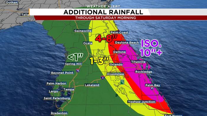
After heavy rain and major flooding earlier this week, another round of severe weather is expected across the region, WKMG reported. The greatest risk of major flooding is east of Orlando, where four to eight inches of additional rain is likely through early Saturday morning, WKMG said.
Isolated rainfall amounts exceeding ten inches are possible east of Orlando from late Thursday night through early Saturday morning, WKMG reported. This incoming moisture arrives on top of rainfall recorded from Tuesday afternoon through Thursday afternoon.
Developing Low Pressure System
Uncertainty remains regarding the highest rainfall amounts on Friday as an area of low pressure develops off the south Florida coast. A track closer to Florida will enhance rainfall on Friday, while a track farther east will help reduce rainfall totals, according to WKMG.
The track closer to Florida appears to be the more likely scenario. Regardless of the exact track, saturated ground and swollen rivers mean it will not take much rain for dangerous flash flooding to begin.

The St. Johns River is already at historic levels across parts of Central Florida. Any additional water will cause the river to rise again.
Coastal Impacts and Regional Totals
Heavy rain became more widespread through Central Florida on Wednesday, with the highest flood threat materializing east of Orlando from Thursday morning through Friday, according to gmg-wkmg-prod.cdn.arcpublishing.com. A widespread five to ten inches of rain was expected along and near the coast through early Saturday morning.
Isolated double-digit rainfall totals were possible from Palm Coast to Cocoa, while impacts were expected to be little to none west of Orlando. Rainfall would begin to end late Friday night before shutting off completely later Saturday, according to gmg-wkmg-prod.cdn.arcpublishing.com.
A flood watch went into effect across much of East Central Florida as repeated rounds of showers and downpours moved through. The Weather Prediction Center placed East Central Florida under a Marginal to Slight Risk for excessive rainfall, with much of the coast under a Level 3 out of 4 Moderate Risk on Wednesday.

Persistent Onshore Winds
Easterly winds featured sustained speeds around 15 to 20 mph with gusts reaching 25 to 30 mph, bringing locally gusty winds of 30 to 45 mph and occasional lightning with heavier downpours. Persistent onshore winds created hazardous marine conditions along the coast, building rough, pounding surf and minor beach erosion.
Communities dealing with high water along the St. Johns River will see water levels take time to recede, leaving some areas vulnerable even as the latest rounds of rain move through.
The St. Johns River is the longest river entirely within Florida, stretching 310 miles and draining a basin of 8,840 square miles. Its elevation drops less than 30 feet from headwaters to mouth, giving it a slow flow often described as “lazy” and a long backwater that ebbs and flows with Atlantic tides.
The watershed supports 3.5 million people and includes the Floridan aquifer, a primary fresh water source for populations north of St. Petersburg. Designated an American Heritage River in 1998, it was also listed among America’s Ten Most Endangered Rivers in 2008 following decades of pollution and alteration for development.
The flood watch was expected to continue through Friday evening, leaving authorities and residents monitoring whether the developing low-pressure system off the south Florida coast tracks closer to land and pushes additional moisture ashore.