Sulawesi Sea Earthquake Triggers Tsunami Warnings Across Asia
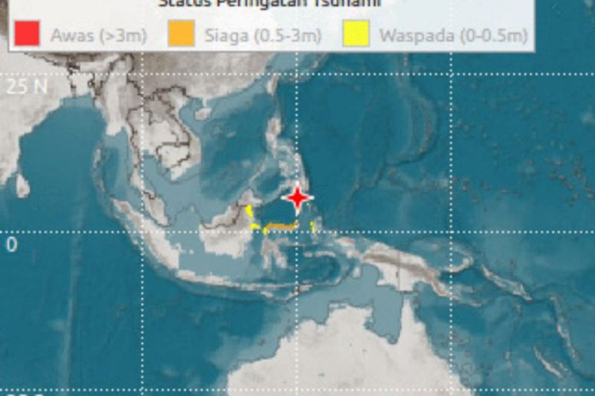
A 7.7-magnitude earthquake struck the Sulawesi Sea on June 8, 2026, at 07:26 local time, prompting Indonesia’s Meteorology, Climatology, and Geophysical Agency (BMKG) to issue and later lift a tsunami warning after assessing minimal risk. The quake, centered near the Molucca Sea, follows a pattern of seismic activity in the region, raising urgent questions about infrastructure resilience and disaster preparedness in coastal communities.
Why was the tsunami warning issued—and why was it lifted so quickly?
The BMKG’s decision to issue a tsunami warning within minutes of the quake reflects Indonesia’s hardened protocols since the devastating 2018 Palu earthquake and tsunami, which killed over 4,300 people. The agency’s real-time seismic monitoring network detected the quake’s shallow depth (approximately 10 km) and strike-slip faulting—characteristics that historically correlate with lower tsunami risk compared to subduction-zone quakes. However, the initial warning triggered evacuations along Sulawesi’s northern coast, including in Bitung and Manado, where tsunami sirens blared and residents rushed to designated safe zones.
“The warning was a precautionary measure,” said Dr. Ir. Dwikorita Karnawati, BMKG’s Head of Meteorology, in a statement to ANTARA News. “Our models showed a 10% probability of a minor tsunami wave, but follow-up buoy data confirmed no significant displacement. We prioritize saving lives over false alarms.”
This rapid escalation and de-escalation underscores a critical tension: balancing public trust in early warnings with the economic and psychological toll of unnecessary evacuations. In 2023 alone, Indonesia’s tsunami false alarms cost an estimated $12 million in lost productivity per event, according to the World Bank. The BMKG’s decision to lift the warning after 47 minutes—once buoy data ruled out a tsunami—demonstrates the agency’s reliance on integrated seismic-buoy systems, a system still under development in many Pacific Rim nations.
Where does this earthquake fit in Sulawesi’s seismic history—and what risks remain?
Sulawesi sits atop a complex tectonic junction where the Sunda Plate interacts with the Molucca Sea microplates, creating a hotspot for shallow, destructive quakes. The region’s last major event, a 7.5-magnitude quake in September 2018, killed 4,300 people and triggered the deadly Palu tsunami. Unlike that event—which occurred on a subduction zone—the June 8 quake originated from strike-slip faulting along the Palu-Koro fault system, reducing tsunami risk but increasing the likelihood of ground liquefaction and landslides.
Key seismic precedents in Sulawesi:
- 2018 (M7.5 Palu earthquake): 4,300+ deaths, $3.9 billion in damages (World Bank). Triggered by subduction, not strike-slip.
- 2021 (M6.2 Mamuju earthquake): 103 deaths, primarily from building collapses. Strike-slip faulting.
- 2024 (M6.8 North Sulawesi): 12 injuries, no tsunami. Demonstrated improved early warning response.
The June 8 quake’s epicenter—approximately 150 km northwest of Manado—placed it in a zone with sparse seismic stations. This gap highlights a persistent vulnerability: Indonesia’s tsunami detection infrastructure remains concentrated along high-risk subduction zones (e.g., Sumatra, Java), leaving strike-slip-prone regions like Sulawesi with patchy coverage. “The Molucca Sea is a blind spot,” warned Prof. Bambang H. S. Purnama, a geophysicist at the Bandung Institute of Technology, in a 2025 interview with The Jakarta Post. “We need denser networks to detect strike-slip events in real time.”
What immediate impacts are coastal communities facing—and how long will they last?
While the tsunami threat has passed, the quake’s shallow depth and proximity to populated areas have triggered secondary hazards. In Bitung, a port city of 150,000, reports indicate minor structural damage to unreinforced brick buildings, a common vulnerability in Indonesia’s older urban centers. The Ministry of Public Works has dispatched inspection teams to assess lifeline infrastructure, including water pipelines and electrical grids, which are particularly fragile in Sulawesi’s karst topography.
“The real test will be the next 72 hours,” said Sutopo Purwo Nugroho, a disaster mitigation specialist at the National Disaster Management Authority (BNPB). “Liquefaction is likely in low-lying areas near the coast. We’re advising residents to avoid digging or moving heavy objects until geotechnical teams complete their assessments.”
Economically, the quake’s impact is already rippling through Sulawesi’s key sectors:
- Tourism: The Wakatobi Marine National Park, a UNESCO site generating $80 million annually, has seen dive operators cancel bookings pending structural safety checks.
- Agriculture: The North Sulawesi coffee belt, which produces 12% of Indonesia’s arabica beans, reports cracked irrigation channels in Tomohon District.
- Fisheries: The Molucca Sea tuna fishery, valued at $250 million/year, faces disrupted operations as boats avoid quake-affected ports.
For businesses and municipalities, the immediate priority is rapid damage assessment. Local governments are turning to drone-based infrastructure mapping firms like PT Aeroindo to identify at-risk areas. “We’re seeing a 30% surge in requests for aerial surveys since the quake,” said Rudi Hartono, Aeroindo’s CEO. “Mayors don’t have time for manual inspections—they need data to prioritize evacuations and repairs.”
How can businesses and residents prepare for aftershocks—and what legal protections exist?
Indonesia’s Disaster Management Law (No. 24/2007) mandates that local governments maintain 72-hour emergency stockpiles and evacuation plans. However, enforcement varies: North Sulawesi Province has only 45% compliance with these requirements, according to a 2025 audit by the Corruption Eradication Commission (KPK). This gap leaves communities vulnerable to prolonged disruptions.
For residents, the BMKG recommends:
- Securing heavy furniture to walls with earthquake-resistant straps (available from local hardware stores like Tokopedia’s verified sellers).
- Registering with community-based disaster response teams (e.g., Posko volunteers in Manado).
- Storing three days of non-perishable food and water—a critical buffer given Sulawesi’s limited road networks.
Businesses, meanwhile, are grappling with insurance coverage gaps. The Indonesian Earthquake and Tsunami Insurance Pool (ITIP) covers structural damage but excludes business interruption losses. “We’re advising clients to supplement ITIP with private parametric insurance,” said Yohanes Suryo, a risk management attorney at SSEK Law Firm. “The pool’s payouts are slow—companies need immediate liquidity to reopen.”
The bigger picture: Why Sulawesi’s seismic risks demand urgent investment
The June 8 earthquake is the latest in a decade-long trend of increasing seismic activity in the Molucca Sea, a region where the Sunda Plate and Molucca Sea Plate grind past each other at a rate of 6 cm/year. While strike-slip quakes like this one are less likely to generate tsunamis, their shallow depths amplify ground shaking—posing a greater risk to unreinforced masonry buildings, which make up 68% of Sulawesi’s housing stock (per the 2023 National Housing Census).
“This is a wake-up call for Indonesia’s urban resilience strategy,” said Dr. Aditya Guswanto, a structural engineer at the University of Indonesia. “We’ve spent billions on tsunami barriers, but strike-slip zones are still an afterthought. The next big quake could be in Gorontalo or Southeast Sulawesi—areas with even less preparedness.”
To address this, the World Bank and Asian Development Bank (ADB) are pushing for a $1.2 billion regional seismic retrofit program, targeting:
- Schools and hospitals in high-risk zones (priority: Manado, Bitung, Palu).
- Port infrastructure in Bitung and Kendari, critical for Sulawesi’s $3.2 billion/year trade volume.
- Early warning system expansion to strike-slip-prone areas.
For now, Sulawesi’s coastal communities are bracing for aftershocks—some as large as M5.0—while grappling with the economic fallout. The quake has exposed a hard truth: Indonesia’s disaster preparedness is tsunami-focused, leaving other seismic threats dangerously underfunded. As Dr. Karnawati put it: “We’ve learned to fear the ocean. Now we must fear the ground beneath us.”
Need verified professionals to help your business or community navigate this crisis?
- [Emergency Restoration Contractors] – For rapid infrastructure repairs.
- [Disaster Response Law Firms] – To navigate insurance claims and legal protections.
- [Seismic Risk Assessment Firms] – To audit building safety and retrofit plans.
This story will be updated as new data emerges. For real-time alerts, monitor BMKG’s seismic dashboard.