Storms Forecast to Return to AMBA This Friday with High Chance of Afternoon Thunderstorms
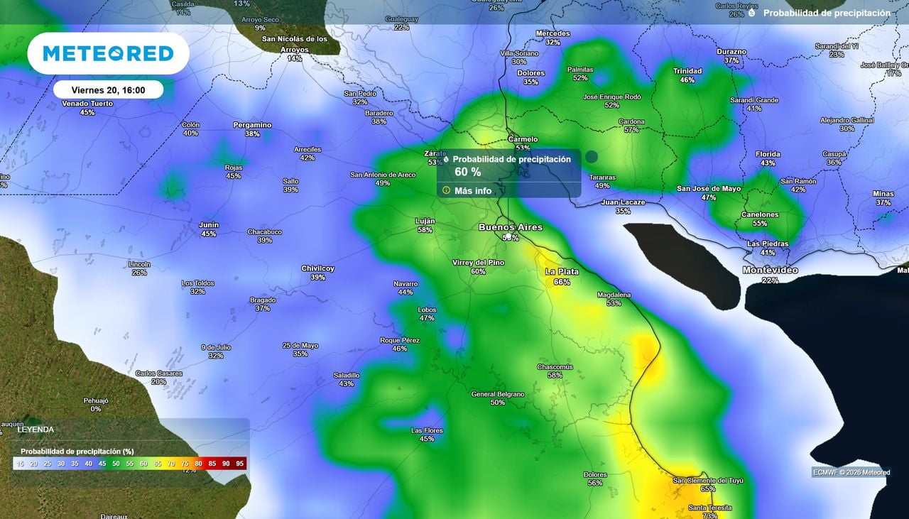
Storms return to the Buenos Aires metropolitan area (AMBA) on Friday, November 20, with the afternoon carrying up to a 70 percent chance of thunderstorms, according to Argentina’s National Meteorological Service (SMN). The agency has not yet placed AMBA under its yellow storm alert, but an extension in upcoming updates remains possible.
A brief break in the weather ends Friday. Meteored Argentina reported that the atmosphere over AMBA has not stabilized, partly because a slow-moving center of low pressure sits off the Buenos Aires coast, while disturbances moving east from the Pacific keep feeding upward motion and storm formation.
Thursday offered the pause. Derecho Diario reported a dry day in the city and surrounding districts with a top temperature of 29 degrees, variable cloud and no rain. Friday is different: Meteored Argentina expects rain and thunderstorms to return, with temperatures between 20 and 26 degrees.
Could SMN put AMBA back on alert?
Not yet. As of Thursday evening, the yellow alert for strong storms covered parts of southeastern Buenos Aires Province and eight other provinces, Meteored Argentina reported, and AMBA was outside it. The outlet noted the warning could be extended to include the capital region in coming updates.
MDZ Online added detail on where the warnings do apply: sectors of the northeast of the country, eastern and southeastern Buenos Aires Province, the central region and Patagonia. For Friday, it reported instability concentrating from early morning in the northeast and during the afternoon along the Buenos Aires coast.

The alert map can change quickly. The SMN posts current warnings on its official alerts page, and both Meteored Argentina and MDZ Online flagged that readers in AMBA should watch for updates before Friday afternoon, when storm chances peak.
What timing should Friday planners expect?
The afternoon is the risky window. Derecho Diario, citing SMN forecasts, put morning shower chances at 10 to 40 percent, rising to 40 to 70 percent in the afternoon with a high of 26 degrees, and easing back to 10 to 40 percent overnight.
Meteored Argentina’s trusted model, the ECMWF, does not currently anticipate significant rainfall accumulations for AMBA on Friday. That gap matters: Derecho Diario’s piece, built on the SMN’s own probability figures, is more cautious than Meteored Argentina’s model-based read, and the two outlets frame the same day differently — one as a storm-heavy afternoon, the other as rain without major totals.
Lightning is part of the forecast picture. Meteored Argentina cited ECMWF lightning-density output for Friday at 7 p.m., pointing to electrical activity in the evening hours.
How does the long weekend stack up?
Saturday through Monday look mostly workable, with one wrinkle each day. Meteored Argentina and Derecho Diario agree Saturday starts near 16 to 17 degrees with possible fog in parts of Greater Buenos Aires, though Meteored Argentina warns rain could return Saturday night while Derecho Diario reports no rain expected that day.

The outlets also differ slightly on Sunday. Meteored Argentina keeps a low chance of weak precipitation, while Derecho Diario puts rain probability at zero for the afternoon and evening. Both place highs in the mid-20s.
| Day | Low | High | Rain risk |
|---|---|---|---|
| Friday, Nov. 20 | 19°C | 26°C | Up to 70% in afternoon |
| Saturday, Nov. 21 | 16–17°C | 26–27°C | Possible night rain (Meteored) |
| Sunday, Nov. 22 | 16–18°C | 25–26°C | Low to none |
| Monday, Nov. 23 | 17°C | 28°C | Possible night instability (Meteored) |
Monday, the last day of the long weekend, warms to around 28 degrees with variable cloud, and Meteored Argentina expects instability could return at night.
When does genuinely stable weather arrive?
Not before late Tuesday. Meteored Argentina, citing ECMWF projections, reported that a considerably drier air mass would arrive only toward the end of Tuesday, November 24, allowing a more sustained stabilization after days of unstable spells followed by temporary improvements.
Until then, the pattern holds. The low pressure off the coast and the Pacific disturbances keep regenerating storm chances, which is why each improvement in the forecast has tended to be temporary.
What does this mean for Buenos Aires residents?
The practical stakes sit in the Friday afternoon commute and outdoor plans. Derecho Diario advised people with outdoor activities or travel to watch conditions between mid-afternoon and early evening. MDZ Online framed the weekend the same way for the holiday crowd: not canceling plans, but choosing hours carefully.
Storms of this kind bring the usual local risks in AMBA — lightning, brief downpours and short power or transit disruptions. When damage does occur, municipal civil defense services are the professionals who handle the aftermath.
For the wider country, the contrast is sharper. MDZ Online projected accumulations near 90 millimeters in Posadas through Tuesday night, against roughly 20 millimeters in Santa Fe, 15 in Rosario and about 20 on the Buenos Aires coast, with Friday storms possibly topping those marks in isolated spots, according to Mdzol.
AMBA, the Buenos Aires metropolitan area, spans the Autonomous City of Buenos Aires plus the 24 surrounding partidos in Buenos Aires Province known as the Conurbano, spreading south, west and north of the city with the River Plate as its eastern boundary. The term “Gran Buenos Aires” was first used officially in 1948, when Governor Domingo Mercante signed a bill covering 14 municipalities around the capital.
The metro area now holds some 15 million people — about a third of Argentina’s population — and generates nearly half of the country’s GDP. Between the 1947 and 2022 censuses, the suburban counties grew more than sixfold, expanding to over 3,800 square kilometers, 19 times the area of the city itself.
The next decision on record belongs to the SMN: whether its next alert update extends the yellow warning to AMBA before Friday’s storms arrive. The forecast, per Meteored Argentina, holds rain and thunderstorms for the capital region with temperatures between 20 and 26 degrees.