Severe Cold, Snow, and Rain Alert for Spain: Affected Areas
Spain is facing a drastic weather reversal this weekend as an Atlantic front triggers a temperature plummet of up to 20 degrees. AEMET and meteorologist Roberto Brasero warn of heavy rains and snow falling below 1,000 meters, shifting the country from summer-like warmth to winter conditions by Sunday, April 12.
The transition is not merely a seasonal fluctuation; This proves a meteorological whiplash. For several days, much of the Iberian Peninsula has enjoyed temperatures more characteristic of July than April, with many regions comfortably exceeding 30 degrees Celsius. In Bilbao, the mercury hit 30 degrees, although Madrid saw 29 degrees. It was a period of short sleeves and sunshine that masked the volatility of the coming front.
That warmth was the calm before the storm.
The “Crazy” Shift: From Summer to Winter
The current atmospheric stability is about to collapse. A powerful storm system, currently positioned west of the British Isles, is pushing an extensive active cold front directly toward the Spanish coast. This system will dismantle the warm air mass currently dominating the peninsula, replacing it with a brutal thermal drop.

The timing is precise, and aggressive. While Friday, April 10, remains warm for most, the southwest—specifically Extremadura and western Andalusia—is already seeing the first signs of instability with predicted thunderstorms. By Saturday, the front will penetrate through Galicia and the Cantabrian communities, bringing immediate rainfall to the north.
The temperature crash will happen in stages, but the cumulative effect is staggering. On Saturday, temperatures in the northern half and the center of the country will drop by 6 to 7 degrees. Sunday will bring another decline of 5 to 6 degrees. In certain zones, the total loss of heat over a 48-hour window will reach 20 degrees Celsius.
“In spring we know that weather changes are common, but one as crazy as the one we have in the coming hours, we have seen few times,” warns Roberto Brasero.
This represents not a gradual cooling. It is a sudden descent into winter conditions in the middle of April.
Regional Impact and Geographic Hazards
The front will not hit every region with the same intensity or at the same time, but its reach is comprehensive. The trajectory begins in the northwest and sweeps across the territory, creating distinct hazards based on geography.
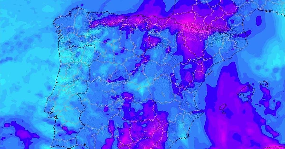
In the northern mountains and the Central System, the primary concern is snowfall. The altitude threshold for snow is dropping significantly, with forecasts indicating snow will fall at levels as low as 700 to 1,000 meters. This poses a direct threat to high-altitude transit and local infrastructure.
As the system moves toward the Mediterranean, the nature of the precipitation changes. The east of the peninsula will experience “muddy rain,” a phenomenon where precipitation mixes with airborne dust, complicating visibility and leaving residue on urban infrastructure and agricultural land.
The movement of the front is summarized as follows:
- Saturday Morning: Entry through Galicia and the Cantabrian coast with heavy rains.
- Saturday Evening: The front reaches the center of the peninsula, triggering the first sharp temperature drop.
- Sunday: Widespread cold, wind, and strong gusts, with the temperature bottoming out across the north and center.
For many, Sunday will feel like a day stolen from January rather than April.
Infrastructure Strain and Professional Solutions
A 20-degree drop in two days creates immediate systemic stress. Residential heating systems that were dormant or set to low during the 30-degree heatwave are now being activated simultaneously across millions of households. This sudden demand often reveals maintenance failures, leaks, or inefficient boilers.
Ensuring that home climate systems are operational is no longer a matter of comfort but of health. Property owners are urgently seeking vetted HVAC technicians to ensure their heating units can handle the abrupt shift to polar temperatures without failure.
Beyond the home, the “muddy rain” in the Mediterranean and heavy snowfall in the Central System create logistical nightmares for municipal drainage and road safety. Saturated soils, a recurring issue in previous Atlantic storms, increase the risk of localized flooding and landslides. When regional infrastructure is compromised by such volatile shifts, securing emergency restoration contractors becomes the critical first step in mitigating property damage and restoring accessibility.
The agricultural sector is perhaps the most vulnerable. A sudden drop to near-freezing temperatures in April can devastate early-season crops and blossoms. Farmers facing potential losses from this “crazy” weather shift are increasingly consulting insurance claims specialists to navigate the complexities of weather-related crop insurance and government subsidies.
A Pattern of Instability
This event is part of a broader, more erratic pattern of Atlantic activity. The AEMET (State Meteorological Agency) has been tracking the movement of these fronts, noting the extreme contrast between the “extraordinary” heat of the past week and the impending cold. The volatility is a reminder of how fragile the transition between seasons has turn into.
The current forecast is a stark warning: the weather is no longer following a linear path. We are seeing a “carousel” of storms and thermal shocks that depart the population and the economy in a state of constant adaptation.
As the front closes in, the priority shifts from enjoying the spring sun to surviving a sudden winter. The danger lies not just in the cold itself, but in the lack of preparation for such a violent swing. Whether it is the snow blocking mountain passes or the mud coating the Mediterranean coast, the coming 48 hours will test the resilience of Spain’s regional infrastructure.
In an era of atmospheric extremes, the only reliable defense is preparation and access to verified expertise. As the temperature plummets, the ability to quickly find and hire qualified professionals—from heating engineers to emergency responders—will be the difference between a manageable weather event and a domestic crisis. The World Today News Directory remains the essential resource for connecting affected citizens with the verified professionals equipped to handle these developing environmental shocks.