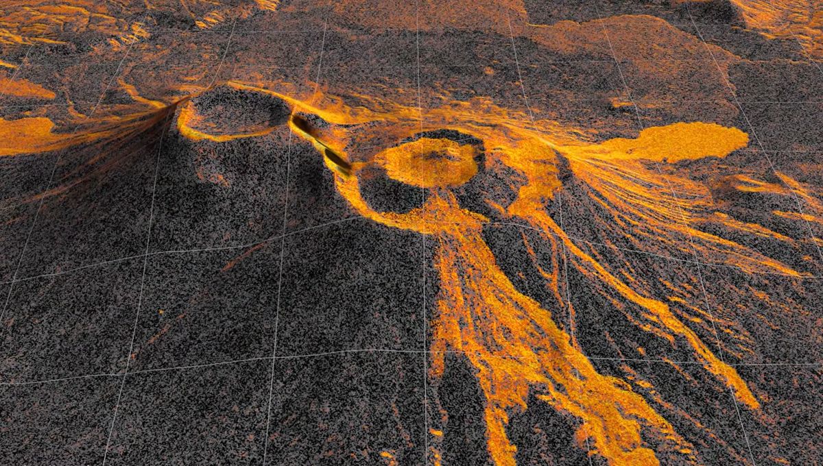
NISAR Satellite Captures First Eruption of Kamchatka Volcano in 500 Years
A dormant volcano pair on the Pacific coast of Russia’s Kamchatka Peninsula began erupting for the first time in nearly 500 years, captured by a satellite project jointly operated by the US and India. The eruption at Krasheninnikov’s northern crater, dormant since 1550 CE, commenced just days after an 8.8 magnitude earthquake struck nearby on July 30, 2025, according to findings discussed by researchers analyzing radar data from the NASA-ISRO Synthetic Aperture Radar (NISAR) spacecraft.
The Tech TL;DR:
- The Event: Krasheninnikov’s northern cone erupted for the first time since 1550 following a July 30, 2025 earthquake, sending a steady flow of lava eastwards.
- The Technology: The NASA-ISRO Synthetic Aperture Radar (NISAR) satellite monitors the site twice every 12 days from an orbit 464 miles above Earth, using dual L-band and S-band radar systems.
- The Data: Researchers compiled 17 radar frames captured through mid-August into a time-lapse animation showing lava filling a caldera and spilling into a fan shape.
Radar Satellite Records Lava Flowing Across Kamchatka
Operating from an orbit 464 miles above the Earth's surface, the NISAR satellite began capturing images of the active volcanic region in December 2025 as it completed post-launch checks. According to iflscience.com, the spacecraft records changes to the terrain twice every 12 days, passing south-to-north and then north-to-south. Each pixel in the individual frames represents a 10-meter-by-10-meter square on the surface of Krasheninnikov.

Researchers aligned 17 radar snapshots taken through mid-August to build a sequence showing lava filling a smaller caldera before overflowing into a larger crater and widening into a fan shape. Earth.com reported that while the time-lapse records the path of the molten rock and debris, whether the 8.8 magnitude earthquake directly triggered the eruption remains an open question for scientific teams studying the fault’s rupture.
Dual-Band Radar Penetrates Tree Canopies and Cloud Cover
NISAR is the first free-flying space mission carrying two distinct synthetic aperture radar instruments—an L-band system and an S-band system developed using processing techniques pioneered by NASA’s Jet Propulsion Laboratory. The L-band radar utilizes longer waves capable of penetrating tree canopies to image the ground underneath, while the S-band observes the leaves of the canopy itself, depending on size. Because radar relies on microwave pulses rather than optical light, it pierces through cloud cover, ensuring data collection continues during storms.
“The consistency is crucial,” Matthew Pritchard, a geophysicist at Cornell University and member of the NISAR science team, explained in a statement cited by iflscience.com. “Twice every 12 days, acquiring in this high-resolution mode and in two observation directions, this shows the promise of NISAR to closely monitor natural hazards.” Pritchard added that historical data for remote volcanoes like those in Kamchatka was far scarcer when he conducted doctoral research more than 20 years ago.
# Conceptual SAR Data Pipeline Processing Check
import numpy as np

def process_sar_frame(l_band_signal, s_band_signal, resolution_meters=10.0):
    # Merge multi-directional passes (ascending/descending)
    combined_signal = np.add(l_band_signal, s_band_signal)
    pixel_grid = combined_signal / resolution_meters
    return pixel_grid
Geological Context in the Ring of Fire
Kamchatka sits within the geologically active Ring of Fire and hosts over 300 volcanoes, of which 29 are currently active. While frequently erupting peaks receive close observation from ground instruments, Krasheninnikov remained largely ignored due to its nearly five centuries of silence. The Global Volcanism Program at the Smithsonian Institution dates the volcano’s previous activity to approximately 1550 CE, according to Earth.com.
Improvements in satellite monitoring technology have expanded observation capabilities across the globe. “We’re seeing volcanoes around the world that we’ve never really had eyes on like this before,” Pritchard stated, noting how cloud storage now allows researchers to access detailed radar snapshots quickly.