July 4th Forecast: Extreme Heat and Storms Expected in Tri-State Area
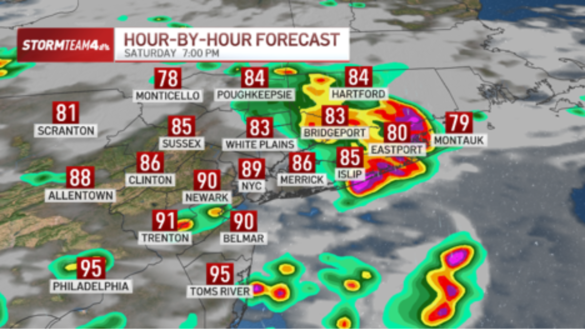
Tri-state area residents face a combination of triple-digit heat indices and sudden thunderstorms on July 4, 2026, according to NBC New York. While temperatures will reach the mid-90s in New York City and low 100s in Central and South Jersey, storms are forecast for Saturday afternoon and evening, potentially disrupting outdoor fireworks and barbecues.
The immediate problem is a clash between an intense dome of high pressure and an incoming weather shift. For millions of people across New York, New Jersey, and Connecticut, this means the holiday window is narrow. The heat isn’t just uncomfortable; it is a public health risk. When the heat index hits triple digits, the body struggles to cool itself, making outdoor exertion dangerous.
This atmospheric volatility creates a specific set of liabilities for event organizers and homeowners. Heavy downpours and strong winds can turn a backyard celebration into a safety hazard in minutes. Those managing large-scale public displays often have to coordinate with [Emergency Management Services] to determine if lightning risks necessitate a full cancellation or a temporary delay.
Why are storms hitting during the July 4th window?
The extreme heat dominating the week is caused by a high-pressure dome. According to NBC New York, this dome will begin to retreat on Saturday. As the pressure drops, it opens a corridor for moisture and instability to move in, triggering storms specifically during the mid-afternoon and evening hours.

The timing is precise and problematic. The forecast indicates that the highest probability for thunderstorms coincides with the “prime time” for Independence Day activities. However, the rain will not be constant. The region will remain largely dry and hot for most of the day, with storms appearing as isolated cells.
These cells are expected to be intense but brief. NBC New York notes that similar to the patterns seen on Friday evening, these storms will likely last between 30 minutes and an hour before moving along. The primary threats are lightning, very strong winds, and heavy downpours.
How will the heat and rain impact regional safety?
The heat index—the perceived temperature when humidity is factored in—will reach the low triple-digits for much of the tri-state area. Health officials typically advise limiting outdoor activity when indices reach this level to avoid heat exhaustion and heatstroke.

When these temperatures collide with sudden thunderstorms, the risk of flash flooding increases. Saturated ground or overwhelmed urban drainage systems in cities like Newark or New York City can lead to immediate street flooding. For those hosting events, the transition from 100-degree heat to a violent thunderstorm creates a chaotic environment for crowd control and equipment safety.
Property owners are increasingly relying on [Weather-Resistant Construction Specialists] to ensure that temporary structures, such as event tents and stages, can withstand the “very strong winds” predicted by meteorologists. A sudden gust during a fireworks display isn’t just a logistical nuisance; it is a significant safety liability.
Forecast Breakdown for July 4-5, 2026
- Saturday (July 4): Mid-90s (NYC) to low 100s (NJ). High humidity. Storms likely mid-afternoon through evening.
- Sunday (July 5): Mid-80s. Cooler conditions. Isolated storms possible late in the day.
What are the risks for outdoor fireworks displays?
Lightning is the primary deterrent for fireworks. Most municipal guidelines require the cessation of pyrotechnic displays if lightning is detected within a specific radius of the launch site. Because the forecast calls for “lightning and very strong winds,” many scheduled events may face delays.
The volatility of the wind also poses a risk to the trajectory of fireworks. Strong gusts can push debris or shells off-course, increasing the risk of structural fires in residential areas. In such cases, the rapid response of [Fire Prevention and Safety Consultants] becomes critical to mitigate the risk of urban fires during the holiday.
To manage these risks, NBC New York recommends that residents use live radar tools and enable weather alerts to receive immediate warnings of severe weather moving over their specific location.
What happens to the weather after the holiday?
The retreat of the high-pressure dome on Saturday marks the end of the current withering heat wave. By Sunday, July 5, conditions will shift significantly. Highs are expected to drop to the mid-80s, providing a reprieve from the triple-digit heat indices of the previous days.

While the temperature drops, the atmosphere remains somewhat unstable. There is a continued chance for isolated storms late Sunday, though they are not expected to be as disruptive as the Saturday evening window.
This transition underscores the erratic nature of mid-summer weather in the Northeast. The shift from extreme heat to storm-driven cooling is a common pattern, but the timing—landing exactly on the nation’s largest summer holiday—amplifies the economic and social impact on the region.
As the tri-state area moves from the danger of heatstroke to the risk of flash floods, the ability to pivot quickly is the only way to ensure safety. Whether it is adjusting the timing of a municipal parade or securing a backyard canopy, the unpredictability of this July 4th forecast demands professional vigilance. For those dealing with the aftermath of storm damage or heat-related infrastructure failure, finding verified experts through the World Today News Directory ensures that recovery is handled by licensed and vetted professionals.