Greenland Landslide Triggered Global ‘Crustal Heartbeat’ – Mega-Tsunami Explained
A slow, steady pulse detected by seismic sensors around the globe for nine consecutive days originated from a massive landslide in eastern Greenland, an event that sent a mega-tsunami surging through Dickson Fjord. Every 92 seconds, the rhythm returned, a signal unlike that of a typical earthquake, baffling scientists until recently.
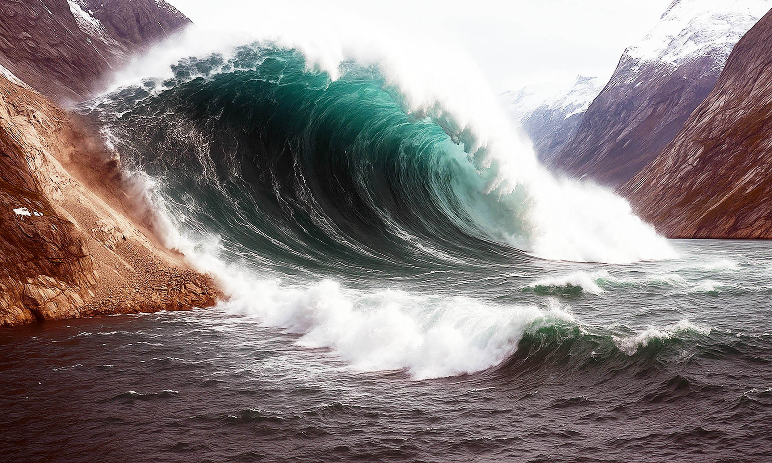
Investigators pinpointed the source to Dickson Fjord, a narrow channel flanked by cliffs reaching approximately 3,000 feet. Satellite imagery revealed a significant section of mountain had collapsed, triggering the unusual seismic activity. On September 16, 2023, over 25 million cubic yards of rock and ice – equivalent to the volume of 10,000 Olympic-size swimming pools – plunged into the fjord.
The impact generated a mega-tsunami reaching heights of around 650 feet. The surge traveled the two-mile length of the fjord, rebounding off a headland and causing damage to equipment at a remote research post on Ella Island, estimated at $200,000. The water didn’t settle after the initial wave; instead, it oscillated back and forth, a phenomenon known as a seiche, with the surface rising and falling as much as 30 feet in a consistent rhythm that exerted pressure on the seafloor.
Unlike the erratic patterns typically recorded during earthquakes, seismic stations registered smooth, repeating peaks spaced 90 seconds apart, maintaining their strength for nearly two weeks. Initial estimates of the seiche’s height varied, ranging from 8½ feet to 23-30 feet, due to differing assumptions about the fjord’s shape, but all models agreed on the landslide as the initiating event. Alice Gabriel of UC San Diego’s Scripps Institution of Oceanography described the challenge of accurately simulating the long-lasting tsunami, stating, “It was a big challenge to do an accurate computer simulation of such a long-lasting, sloshing tsunami.”
The investigation, involving over seventy researchers from forty-one institutions, revealed fresh gouges on the cliffsides and utilized supercomputers to recreate the avalanche and the fjord’s response. “When we set out on this scientific adventure, everybody was puzzled and no one had the faintest idea what caused this signal,” said Kristian Svennevig of the Geological Survey of Denmark and Greenland. “All we knew was that it was somehow associated with the landslide. We only managed to solve this enigma through a huge interdisciplinary and international effort.” Robert Anthony of the U.S. Geological Survey added, “It was exciting to be working on such a puzzling problem with an interdisciplinary and international team of scientists…it took a plethora of geophysical observations and numerical modeling from researchers across many countries to position the puzzle together and get a complete picture of what had occurred.”
Scientists attribute the landslide to the effects of a warming climate and melting glaciers, which had previously provided support to the unstable slope. “Climate change is shifting what is typical on Earth, and it can set unusual events into motion,” Gabriel noted. A similar event in Karrat Fjord in 2017 resulted in a deadly tsunami that destroyed eleven homes and caused four fatalities.
Dickson Fjord lies near a frequently traveled cruise route. While no vessels were present during the September 2023 event, authorities are now reviewing early-warning systems that integrate satellite data with real-time seismic monitoring. The launch of the Surface Water and Ocean Topography (SWOT) mission in December 2022, which maps a 30-mile-wide swath with 8-foot resolution, represents a significant advancement in monitoring such remote regions. Thomas Monahan of the University of Oxford explained, “Climate change is driving the emergence of unprecedented extremes, particularly in remote regions like the Arctic, where our ability to monitor conditions using traditional physical sensors is limited…SWOT represents a breakthrough in our ability to study oceanic processes in areas such as fjords.”
Researchers are now analyzing seismic archives for similar slow pulses, potentially uncovering previously undetected natural disasters. Carl Ebeling of Scripps stated, “This shows there is stuff out there that we still don’t understand and haven’t seen before…The essence of science is trying to answer a question we don’t know the answer to – that’s why this was so exciting to operate on.” The findings, published in the journals Science and Nature Communications, will contribute to refining models of slope failure, fjord geometry, and water depth interactions, with the goal of improving disaster forecasting in high-latitude waters.