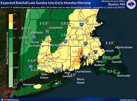
Fast-Moving Storm Brings 1-3 Inches Rain, 45 MPH Gusts to Southern New England Late Sunday Into Monday
A fast-moving coastal low will bring 1 to 3 inches of rain and wind gusts up to 45 mph to southern New England late Sunday into Monday morning, the National Weather Service in Boston said Saturday.
The heaviest rain is expected east of the Connecticut River to near the Interstate 95 corridor, though the exact axis could shift slightly east or west, Fall River Reporter reported. Showers may arrive by late Sunday afternoon, but the bulk of the precipitation falls overnight and should exit the coast by the Monday morning rush hour.
Moisture levels ahead of the system are running 290 to 330 percent of normal, according to the Area Forecast Discussion issued by NWS Boston at 6:56 p.m. Saturday. That plume, combined with strong forcing from a mid-level trough, primes the atmosphere for heavy rainfall rates in a short window.
“Models continue to stay in general agreement with the development of a low pressure system off the southeast coast this weekend, later phasing with a mid-level trough over the northeast,” the discussion said. The low is projected to track across or near the Cape and Islands overnight Sunday into early Monday.
Wind threat focused on Cape and Islands
Southeast wind gusts of 25 to 45 mph are possible along the coast Sunday night, with the strongest gusts near the Cape and Islands, the Weather Service said. A southerly low-level jet of 50 to 60 knots will sit near the region, though a nighttime inversion should limit how much of that momentum mixes to the surface.
Ensemble guidance shows a 40 to 70 percent probability of gusts reaching 40 mph or greater for the Cape and Islands, with lower probabilities along the immediate south coast and southeastern Massachusetts, according to the forecast discussion. A more westerly track would bring stronger gusts to coastal waters and parts of the south coast.
Flooding risks limited by storm speed
Forecasters said the system's progressive nature should limit major flooding. Brief nuisance street flooding from poor drainage is possible during the heaviest rain. Splashover or very minor coastal flooding is also possible Monday morning, though significant coastal impacts are not anticipated.
“Given the progressive nature of the system, flash flood risk is low, although can’t rule out ponding of water or urban/poor drainage flooding,” the discussion said. Deterministic and ensemble guidance consistently show a swath of 1 to 3 inches across southern New England.
Thanksgiving nor’easter looms as next threat
Forecasters are also watching a potential nor’easter late Wednesday night into Thanksgiving, the Weather Service said. That system could bring mainly rain and strong coastal winds, with some snow or ice at the onset for interior areas, especially higher elevations.
Strong winds with dangerous marine conditions are likely, and coastal flooding is possible with the Thanksgiving system, according to the key messages in the forecast discussion. The threat continues to be monitored.
Timeline and travel impacts
Rain arrives late Sunday afternoon, intensifies Sunday night, and tapers off by mid-morning Monday, the Weather Service said. The Monday morning commute may see residual wet roads and ponding in low-lying areas. Residents should monitor updated forecasts through the weekend, particularly for the Thanksgiving system.
“The magnitude of the gusts will depend on the finer details such as the track/strength of the low,” the forecast discussion said.
The Cape and Islands region encompasses Barnstable County on Cape Cod, Dukes County including Martha’s Vineyard and the Elizabeth Islands, and Nantucket County.
The name Cape Cod, coined in 1602 by Bartholomew Gosnold, is the ninth-oldest English place-name in the U.S. Since 1914, the Cape Cod Canal has separated most of the peninsula from the mainland, leading many state and federal agencies to treat the Cape as an island for disaster preparedness and groundwater management.
The next forecast update from NWS Boston will incorporate new model guidance overnight Saturday into Sunday.