Climate, Seismic Forces Drive Alaska Bedrock Landslide Risks
Rapid climate-driven landscape changes are increasing the frequency of large-scale bedrock landslides in southern Alaska, threatening coastal infrastructure and cruise ship transit routes.
The stability of steep rock slopes in the region relies heavily on ice-filled discontinuities that act as natural buttresses. As mean annual temperatures rise, these ice bonds weaken, leaving bedrock susceptible to deformation. This process, often described as paraglacial adjustment, creates a “delayed response” where slopes remain unstable long after the initial glacial retreat occurs, according to studies by M.C. Spreafico and colleagues.
The danger posed by these deformations was highlighted when a landslide-generated tsunami occurred at Pedersen Lagoon on August 15, 2024. This event followed a series of documented instabilities, including a 481-meter-high landslide-tsunami in a fjord frequently visited by cruise ships, which was detailed in a 2026 Science article by D.H. Shugar and co-authors.
The risk is not limited to glacial retreat. Seismic activity continues to trigger failures in already compromised bedrock. The Mw7.0 earthquake that struck Yukon, Canada, on December 6, 2025, served as a recent reminder of how tectonic forces can interact with existing geomorphic vulnerabilities to cause large-scale ground failure.
Geological Controls in Southern Alaska
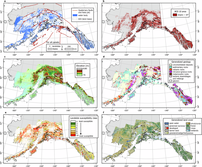
The Alaska Division of Geological & Geophysical Surveys identified widespread susceptibility to deep-seated landslides across the state’s southern mountainous terrain. Researchers utilize satellite interferometry, or InSAR, to map these slow-moving slopes before they reach a critical threshold of failure. This monitoring is vital for identifying areas where rapid landscape modification is occurring.
Permafrost degradation further complicates the mechanical stability of these rock walls. Models developed by M. Krautblatter and others demonstrate that thermo-cryogenic controls directly influence fracture kinematics. As the internal temperature of the rock rises, the displacement rates of large unstable slopes accelerate, often leading to sudden, massive rock slope failures.
Cruise Ships and Planners Confront Fjord Slope Hazards
The intersection of these geological hazards with human activity creates challenges for regional planners and maritime operators. Cruise ship operators and local officials must weigh the risks of navigating fjords where slope instabilities have been identified.
Experts continue to investigate whether the mechanical response of slopes to thermal forcing is sudden or delayed, a distinction that remains critical for long-term hazard forecasting.
Pedersen Lagoon lies on the western shore of Aialik Bay in Kenai Fjords National Park, about 64 miles east-northeast of Homer. It receives freshwater from proglacial lakes of the Addison and Pedersen glaciers descending from the Harding Icefield. The lagoon formed atop a terminal moraine complex marking the Little Ice Age maximum extent of those glaciers.
U.S. Geological Survey personnel named the glacier for Reverend Louis H. Pedersen in 1908, though maps misspelled it “Pederson” until a 2000 correction. By 1950, glacial retreat had created a tidal lagoon; the proglacial lake lengthened to 2 miles by 2016 before the terminus began emerging from the water in 2021. Exposed bedrock consists of the Valdez Group, deformed metasedimentary rocks accreted from a Late Cretaceous deep oceanic trench.
The question of how to effectively monitor these vast, remote areas remains open, as does the determination of which specific coastal corridors require immediate intervention to protect human life and maritime traffic. The extent to which these slope deformations will continue to accelerate under projected climate warming scenarios is not yet fully known.