Climate Change and the Rising Risk of Catastrophic Himalayan Floods
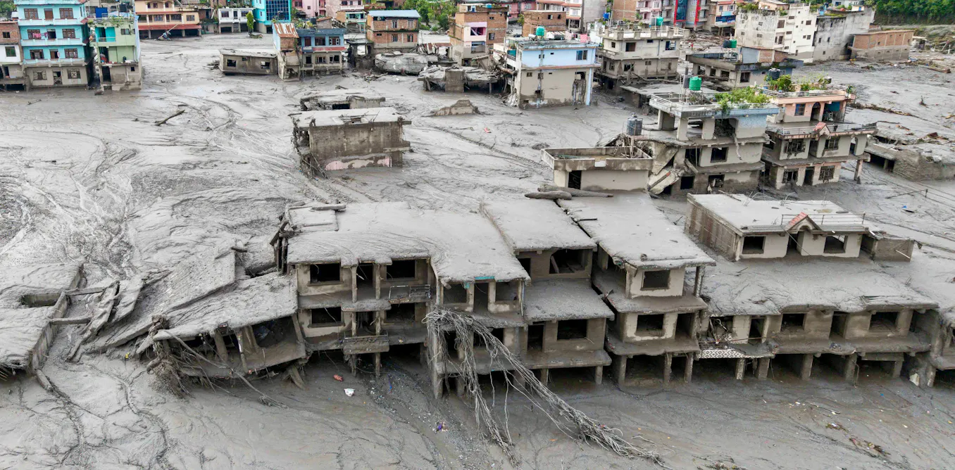
On August 26, 2026, a catastrophic flood struck Nepal, killing hundreds of people and leaving many others missing after an enormous mass of bedrock and glacier ice broke off a slope north of Langtang Lirung. According to satellite imagery and seismic data analyzed by an ad hoc international group of scientists, the resulting debris flow and subsequent barrier lake collapse triggered widespread regional infrastructure failure and severe humanitarian emergency.
The Mechanics of a Himalayan Collapse
The disaster began when an immense volume of glacier ice and bedrock detached from a slope north of Langtang Lirung, plunging roughly 4,000 feet into the valley below. According to the U.S. Geologists noted that the falling ice and rock slammed into the river, temporarily damming the valley before the blockage burst and sent a devastating wall of water downstream.
This dynamic mirrors prior alpine disasters. In 2021, a rock and ice avalanche on Ronti Peak in India’s Uttarakhand state sent approximately 950 million cubic feet of material down the mountain, destroying hydropower infrastructure and leaving about 200 people dead or missing, as documented in scientific post-disaster surveys. Similarly, a 2023 rock collapse into South Lhonak Lake in Sikkim, India, caused an outburst flood that released over 13 billion gallons of water, damaging dozens of bridges and thousands of buildings.
The Secondary Threat of Barrier Lakes
The immediate danger did not end with the initial flash flood. Within a day of the initial catastrophe, authorities warned that a new barrier lake holding millions of cubic meters of water had pooled behind avalanche and flood debris where two rivers meet in Tibet, a region of China, before crossing into Nepal. On August 28, 2026, that barrier lake breached its banks, forcing rescue operations to pause temporarily while residents scrambled to higher ground.
Temporary, debris-choked dams form rapidly, hold water for hours or days, and fail with minimal warning. These avalanche-dammed lakes frequently appear and disappear too quickly for conventional monitoring networks to detect, compounding the risks for downstream communities and complicating emergency response efforts.
Climate Drivers and Permafrost Degradation
Global heating is accelerating these high-mountain hazards. According to studies from the Nepal-based International Center for Integrated Mountain Development (ICIMOD), ice loss rates across the Hindu Kush and Himalayan mountain ranges have roughly doubled since 2000. Rising global temperatures have driven the warmest decade on record, accelerating both snow and glacier melt.
Beyond surface ice, high mountain slopes are stabilized by permafrost—ground remaining frozen year-round where ice fills rock fractures like a natural cement. As temperatures climb and permafrost thaws, this cement weakens. Meltwater infiltrating these fractures can widen cracks through refreezing or lubricate structural fault lines, pushing steep mountain faces past their breaking point. When regional infrastructure is compromised by such sudden events, recovering communities often rely on emergency restoration efforts to clear debris and stabilize affected sites.
Mitigation, Warning Systems, and Regional Risks
Mitigating future disasters requires robust, redundant monitoring infrastructure. While Nepal utilizes river-level warning systems that have successfully prevented casualties during traditional monsoon floods, those systems struggle against fast-moving debris flows and walls of water that can destroy the gauges themselves. Experts emphasize the need for seismic sensors capable of detecting mass movements instantly, along with resilient satellite and radio-based cell broadcasts.

Furthermore, human expansion into fragile mountain corridors for hydropower generation heightens overall exposure. The August 2026 flood knocked about a dozen major generation and transmission facilities offline and destroyed critical infrastructure like the Gyirong Port gateway between Nepal and China. As transboundary hazards continue to evolve, policymakers and developers must account for hanging glaciers, thawing permafrost, and short-lived debris dams when planning high-altitude projects. Navigating these complex regulatory and environmental hazards increasingly requires specialized consultations to safeguard vulnerable valley settlements.
As the long-term impacts of climate change continue to destabilize high-altitude slopes across the Himalayas, regional cooperation remains vital for transboundary disaster management. Communities in high-risk corridors must look to civil engineering firms and municipal authorities to redesign resilient infrastructure capable of withstanding the growing threat of sudden glacial and permafrost collapses.
Worth a look
- Portland Timbers vs. Austin FC Live Stream: How to Watch, TV Channel and Kick-off Time
- Global Crackdowns on Teen Social Media Use Grow Amid Legal Battles
- Trump’s Canada Tariffs: Legal Questions and Rising Trade Tensions (archyde.com)
- Search Continues for 675 Missing in Nepal Floods Amid Devastating Glacier Collapse (time.news)