
Austin Braces for Heavy Rainfall, Flood Threat Over Labor Day Weekend – Cold Front to Bring Relief
Austin, TX – Central Texas is facing a significant risk of flooding through the Labor Day weekend as a stalled frontal boundary brings the potential for heavy rainfall adn slow-moving thunderstorms.the National weather Service warned Friday of “locally heavy rains” and a “marginal risk of flash flooding” extending through monday, especially impacting urban areas and small streams.
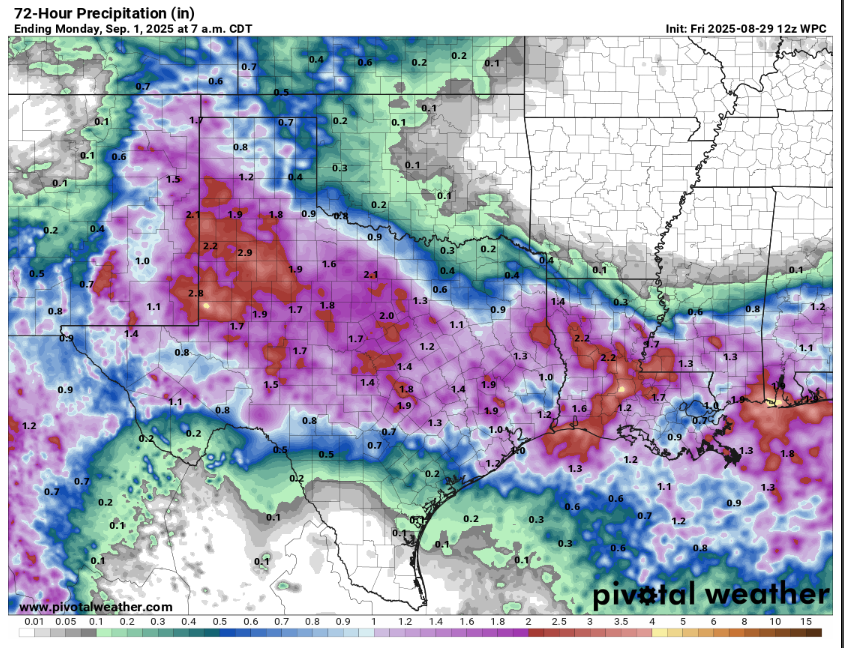
The forecast hinges on three key factors. First,a stalled frontal boundary will create a convergence zone where colliding air masses force warmer air to rise,creating unstable atmospheric conditions ripe for thunderstorm growth. Second, atmospheric moisture – measured as “PWs” or precipitable water – is expected to peak between 2 and 2.25 inches from Saturday afternoon through Monday afternoon. weak steering winds will allow storms to move slowly, and outflow boundaries from individual storms may collide, triggering new storm development or merging existing ones.
These conditions are predicted to produce “rounds of showers and thunderstorms” each afternoon through the holiday weekend, with the highest threat of heavy rainfall occurring Saturday night through Labor Day. Rainfall totals are expected to range from one to three inches across a wide area, with isolated locations perhaps receiving up to five inches.
The Weather Prediction Center has issued flood alerts,initially placing Central Texas,including the Hill Country,under a Level 1 of 4 risk – a 5% chance of excessive rainfall flooding – for Saturday. This threat has been upgraded to a Level 2 of 4 risk, or at least a 15% chance, for Sunday.
While widespread severe weather isn’t anticipated, the strongest storms could produce isolated wind gusts up to 50 mph.
A stronger northerly flow is expected to push a cold front south of austin on Sunday, shifting rain chances to South texas and bringing cooler temperatures. Saturday will remain warm,with highs in the low to mid-90s,dependent on storm development. SundayS high temperatures are forecast to drop into the 80s with the front’s passage.
Authorities urge travelers to monitor road conditions via ATXFloods and to sign up for weather alerts through Warn Central Texas, a City of Austin preparedness program. Residents are advised to remain vigilant and prepared for potential flooding throughout the holiday weekend.