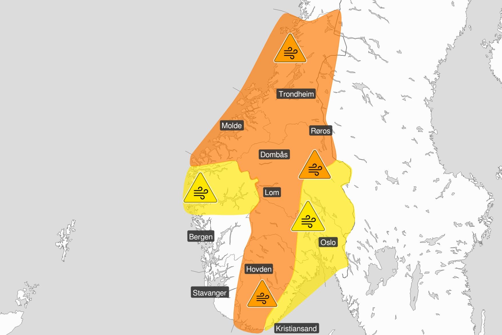
Residents in large parts of southern Norway should clear the hatches and prepare for storms. The wind hits land on Sunday afternoon.
–
– This strong wind is an event that can happen every ten years, says state meteorologist Magnus Haukeland.
The Norwegian Meteorological Institute has issued an orange warning for strong winds with an increase to a full storm on Sunday. The danger warning applies to large parts of southern Norway.
The strongest wind is expected in Møre og Romsdal and south in Trøndelag around 18-19 on Sunday afternoon.
– Just then there will be a marked increase in wind and gusts, up to 43 meters per second. And in an hour or two it can be even more powerful than that, says state meteorologist Haukeland.
The wind will be around 30-40 meters per second in inland areas, and 40-43 meters per second on the coast through Sunday. During the night, the wind will calm down, and it will change to a fresh breeze by Monday evening.
On Sunday morning, the meteorologists extended the danger warning. There will also be strong winds in western parts of Agder, Telemark, Buskerud and Innlandet county.
Heavy rainfall
– In addition to this wind, there is snow and snow showers. There is talk of fairly heavy rainfall, at the same time as the strongest wind, which will mean snow in the inner regions and sleet along the coast, says state meteorologist Magni Svanevik.
The precipitation will result in heavy snowfall in the mountains in southern Norway. In addition, the coast will have a real round of waves. Several meters high waves are expected on Sunday night.
– Night to Monday, it is 10-11 meters towards the coast of Møre og Romsdal and Sør-Trøndelag. It is very loud, says Svanevik.
Ask people to stay inside
– We ask people in Trøndelag to stay indoors on Sunday afternoon and evening. Do away with the necessary driving in advance and attach loose objects, says Chief of Staff Kjell Bergland in Trøndelag police district.
– We expect that roads can be closed and that ferries will be canceled, Bergland warns.
Varsom.no warns that objects may be taken by the wind or blow over, danger of damage to buildings and infrastructure, and canceled departures for ferry, plane or other transport are expected.
Bridges can be closed, many journeys may have a longer travel time, and roads may be closed due to trees or other objects in the roadway.
Snøfokk provides reduced visibility and the possibility of column driving and / or closed roads. High waves can damage infrastructure and buildings in the beach zone, and the strong wind can cause locally high waves in fjord areas and lakes.
In addition they write that the power supply will be affected, for example as a result of trees breaking or coming into contact with the mains.
This is what it looked like when Gyda met Molde last week:
Yellow Østafjells
The weather will not be as violent in Eastern Norway, but meteorologists use a different scale for danger warnings there.
A yellow warning has therefore been sent out for strong winds there as well, with gusts of between 17–23 meters per second in strength.
– There is a lower limit for gusts warning Østafjells as you are less used to strong winds, but it can certainly have consequences. There you can also get, for example, tree falls that block roads or come into contact with the power grid, says state meteorologist Svanevik.
It will be windy in Sogn og Fjordane as well, and a yellow danger warning has been sent out for gusts between 27-35 meters per second in strength.
High risk of avalanches
A lot of rain combined with mild weather and strong winds means that there is a great risk of avalanches in several places in Norway.
On Helgeland in Nordland, large and some very large landslides can be triggered by themselves. Varsom.no writes that there are extensive unstable conditions in the region.
Also in Jotunheimen and Trollheimen there is a great danger of avalanches. The risk of landslides in both areas will increase during the day and evening.
 –
–Network preparedness
Among those who are preparing is the online company Tensio, says media guard Tore Wuttudal.
– We have earlier this week had emergency preparedness in connection with Gyda, and it was completed yesterday afternoon. We are continuously assessing any new emergency preparedness, and follow up on what we did in advance of Gyda – with extra staffing at the network center, review of duty lists and increased staffing at the customer center.
He says they are excited about whether the forecasts are correct, but at the same time advise customers to be prepared.
– They should be confident that we will do our utmost to maintain the power supply, but it may be good to think a little about how to prepare to be without electricity for a few hours, Wuttudal concludes.
–