
Hurricane Erin Intensifies to Category 5, Threatens caribbean and US East Coast
MIAMI, FL – August 16, 2025 - Hurricane Erin has undergone explosive intensification, rapidly evolving into a Category 5 hurricane with maximum sustained winds reaching 160 mph (260 km/h). The storm’s rapid strengthening has prompted urgent warnings from the National Hurricane Center (NHC) and heightened concerns for the Caribbean islands and the eastern United States.
Rapid Intensification and Current Status
The hurricane’s intensification was remarkably swift, jumping from tropical storm strength on Friday to a Category 5 storm within a short timeframe. National Hurricane Center Director Mike Brennan explained during a briefing that erin “explosively deepened and intensified” overnight. This phenomenon, known as rapid intensification, occurs when a storm strengthens by at least 34 mph in a 24-hour period [[1]]. Erin’s winds surged from 100 mph early Saturday morning to 160 mph just hours later.
Did You Know? Rapid intensification is becoming more common as ocean temperatures rise due to climate change, providing more energy for hurricanes to strengthen quickly.
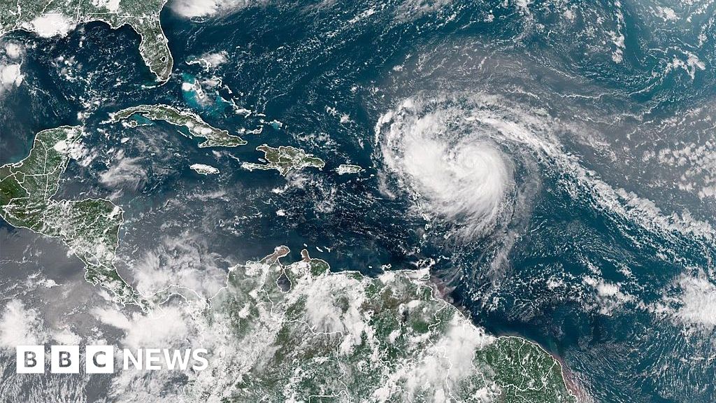
Projected Path and Potential Impacts
Currently, Hurricane Erin is forecast to pass north of the Leeward Islands, the Virgin islands, and Puerto Rico throughout the weekend. While a direct landfall on these islands is not anticipated, the storm is expected to bring torrential rainfall-up to 6 inches (15 cm)-increasing the risk of flash flooding and dangerous mudslides. The US Coast Guard has already imposed restrictions on vessels at ports in St. Thomas, St. John (US Virgin Islands), and six municipalities in Puerto Rico, including San Juan, due to the approaching gale-force winds.
Looking ahead, Erin is projected to move gradually northward, passing east of the Bahamas and towards the Outer Banks of North Carolina next week. Even without making landfall, the storm is expected to generate life-threatening surf and rip currents along almost the entire east coast of the United States. Florida and the mid-Atlantic states are predicted to experience the most hazardous surf conditions. Bermuda is also under threat of life-threatening surf and heavy rainfall.
Key Hurricane Erin Data
| category | Sustained Winds | Location (as of Aug 16, 2025) | Projected Path |
|---|---|---|---|
| Category 5 | 160 mph (260 km/h) | Open Tropical Atlantic | North of Leeward Islands, then towards Outer Banks, NC |
Broader Context: An Above-Normal Atlantic Hurricane Season
The formation of Hurricane Erin marks the beginning of the 2025 Atlantic hurricane season. The National Oceanic and Atmospheric Management (NOAA) has predicted an “above normal” season this year, citing warmer-than-average sea surface temperatures and favorable atmospheric conditions. These conditions are expected to contribute to an increase in the number of tropical storms, with a projected rise in the frequency of storms reaching Category 4 and 5 intensity [[2]].
Pro Tip: Staying informed about hurricane forecasts and heeding warnings from local authorities is crucial for ensuring your safety during hurricane season.
What steps are you taking to prepare for the potential impacts of Hurricane Erin and the broader Atlantic hurricane season? how can communities better mitigate the risks associated with increasingly intense storms?
Understanding Hurricane Formation and Intensification
Hurricanes are powerful tropical cyclones that form over warm ocean waters. They are fueled by the evaporation of water from the ocean surface, which rises and condenses, releasing heat that drives the storm’s circulation. Several factors contribute to hurricane intensification, including warm sea surface temperatures, low wind shear, and a moist atmosphere. Climate change is exacerbating these conditions, leading to more frequent and intense hurricanes.
Frequently Asked Questions About Hurricane Erin
- What is the current status of Hurricane Erin? Hurricane Erin is currently a Category 5 hurricane with sustained winds of 160 mph.
- Is Hurricane Erin expected to make landfall in the US? Current forecasts do not predict a direct landfall on the US mainland, but dangerous surf and rip currents are expected along the East Coast.
- What areas are most at risk from Hurricane Erin? The Leeward Islands, the Virgin Islands, Puerto Rico, Bermuda, Florida, and the mid-Atlantic states are facing potential impacts.
- What is rapid intensification? Rapid intensification is when a hurricane’s wind speeds increase by at least 34 mph within 24 hours.
- what is the outlook for the 2025 Atlantic hurricane season? NOAA predicts an above-normal Atlantic hurricane season with an increased likelihood of major hurricanes.
Stay tuned to world-today-news.com for the latest updates on Hurricane Erin and other developing weather events. We are committed to providing you with accurate, timely, and insightful facts to help you stay safe and informed.